IMAGES TAKEN NEAR TO
Water Park Road, BIDEFORD, EX39 3RN
Introduction
This page details the photographs taken nearby to Water Park Road, EX39 3RN by members of the Geograph project.
The Geograph project started in 2005 with the aim of publishing, organising and preserving representative images for every square kilometre of Great Britain, Ireland and the Isle of Man.

There are currently over 7.5m images from over14,400 individuals and you can help contribute to the project by visiting https://www.geograph.org.uk
Image Map (Loading...)


Getting Data...Please wait
Leaflet Map data © OpenStreetMap
Images are licensed for reuse under creativecommons.org/licenses/by-sa/2.0
Notes
- Clicking on the map will re-center to the selected point.
- The higher the marker number, the further away the image location is from the centre of the postcode.
Image Listing (17 Images Found)
Images are licensed for reuse under creativecommons.org/licenses/by-sa/2.0
Image
Details
Distance
1
The Londonderry Farm Estate on the outskirts of Bideford
Image: © Roger A Smith
Taken: 10 May 2024
0.12 miles
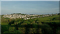
2
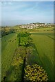
Bideford : Suburb Scenery
Looking towards houses on the outskirts of Bideford.
Image: © Lewis Clarke
Taken: 6 Aug 2023
0.14 miles
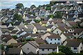
3

Torridge : Bideford Scenery
Looking towards the rooftops of houses on the Bideford suburbs.
Image: © Lewis Clarke
Taken: 15 Nov 2014
0.16 miles
4
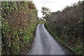
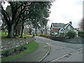
Torridge : Country Lane
A small lane heading into the town of Bideford.
Image: © Lewis Clarke
Taken: 15 Nov 2014
0.16 miles
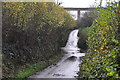
5

Torridge : Country Lane
A small lane where water is covering the tarmac.
Image: © Lewis Clarke
Taken: 15 Nov 2014
0.16 miles
6
Torridge : Country Lane
A small lane heading away from the town of Bideford.
Image: © Lewis Clarke
Taken: 15 Nov 2014
0.16 miles

8
Lodge at the entrance to Moreton Park
The estate is part of an independent school, Grenville College.
Image: © Jonathan Billinger
Taken: 16 Jan 2008
0.18 miles
9

Torridge : Country Lane
A small lane heading through the countryside.
Image: © Lewis Clarke
Taken: 15 Nov 2014
0.19 miles
10
A lane running through Kenwith Valley which joins Northdown Road
Image: © Roger A Smith
Taken: 10 May 2024
0.19 miles