IMAGES TAKEN NEAR TO
Clevelands Park, BIDEFORD, EX39 3QH
Introduction
This page details the photographs taken nearby to Clevelands Park, EX39 3QH by members of the Geograph project.
The Geograph project started in 2005 with the aim of publishing, organising and preserving representative images for every square kilometre of Great Britain, Ireland and the Isle of Man.

There are currently over 7.5m images from over14,400 individuals and you can help contribute to the project by visiting https://www.geograph.org.uk
Image Map (Loading...)


Getting Data...Please wait
Leaflet Map data © OpenStreetMap
Images are licensed for reuse under creativecommons.org/licenses/by-sa/2.0
Notes
- Clicking on the map will re-center to the selected point.
- The higher the marker number, the further away the image location is from the centre of the postcode.
Image Listing (40 Images Found)
Images are licensed for reuse under creativecommons.org/licenses/by-sa/2.0
Image
Details
Distance
1
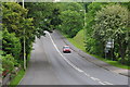
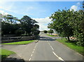
Northam : Heywood Road A386
Looking along Heywood Road as it heads from Northam to Bideford.
Image: © Lewis Clarke
Taken: 1 Jun 2014
0.10 miles
2
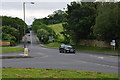
Northam : Heywood Road A386
Looking along Heywood Road at the junction with Churchill Way.
Image: © Lewis Clarke
Taken: 1 Jun 2014
0.10 miles
3
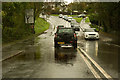
Flood waters on the A386 in Northam
To the east of this point, in a field, "sinks" is marked on the Ordnance Survey map indicating a water course travelling towards the road.
Image: © Roger A Smith
Taken: 26 Oct 2019
0.10 miles
5

Shallow valley on A386 south of Northam
The road drops into the valley of a stream that flows east into the Torridge at Cleave Quay
Image: © David Smith
Taken: 9 Jun 2014
0.12 miles
7

Northam : Heywood Road
Looking along Heywood Road beside the bus stop in Northam.
Image: © Lewis Clarke
Taken: 1 Jun 2014
0.14 miles
8
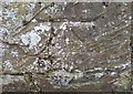
Ordnance Survey Cut Mark
This OS cut mark can be found on the wall east side of Fore Street. It marks a point 60.048m above mean sea level.
Image: © Adrian Dust
Taken: 14 Feb 2017
0.14 miles
9

Horse trough in Northam
Beside the main road from Bideford, now used for flowers
Image: © David Smith
Taken: 9 Jun 2014
0.14 miles