IMAGES TAKEN NEAR TO
Lenwood Road, BIDEFORD, EX39 3PN
Introduction
This page details the photographs taken nearby to Lenwood Road, EX39 3PN by members of the Geograph project.
The Geograph project started in 2005 with the aim of publishing, organising and preserving representative images for every square kilometre of Great Britain, Ireland and the Isle of Man.

There are currently over 7.5m images from over14,400 individuals and you can help contribute to the project by visiting https://www.geograph.org.uk
Image Map
Images are licensed for reuse under creativecommons.org/licenses/by-sa/2.0
Notes
- Clicking on the map will re-center to the selected point.
- The higher the marker number, the further away the image location is from the centre of the postcode.
Image Listing (6 Images Found)
Images are licensed for reuse under creativecommons.org/licenses/by-sa/2.0
Image
Details
Distance
1
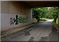
Graffiti art on a bridge on Lenwood Road under the A39
Image: © Roger A Smith
Taken: 26 Sep 2021
0.14 miles
2
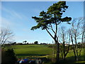
Scots pine and view from Lenwood
The white building on the hill is Gresham Court.
Image: © Jonathan Billinger
Taken: 16 Jan 2008
0.14 miles
3
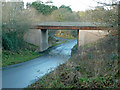
Road bridge at Silford
The A39 crosses a minor road to the north of Bideford.
Image: © Jonathan Billinger
Taken: 16 Jan 2008
0.15 miles
4
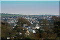
Northam, & East the Water
The white building in the foreground is Fordlands. The houses in the mid ground and beyond are in East the water. Bideford is out of view between the two.
Image: © Roger A Smith
Taken: 25 Mar 2017
0.17 miles

