IMAGES TAKEN NEAR TO
South Lea, BIDEFORD, EX39 3PF
Introduction
This page details the photographs taken nearby to South Lea, EX39 3PF by members of the Geograph project.
The Geograph project started in 2005 with the aim of publishing, organising and preserving representative images for every square kilometre of Great Britain, Ireland and the Isle of Man.

There are currently over 7.5m images from over14,400 individuals and you can help contribute to the project by visiting https://www.geograph.org.uk
Image Map (Loading...)


Getting Data...Please wait
Leaflet Map data © OpenStreetMap
Images are licensed for reuse under creativecommons.org/licenses/by-sa/2.0
Notes
- Clicking on the map will re-center to the selected point.
- The higher the marker number, the further away the image location is from the centre of the postcode.
Image Listing (24 Images Found)
Images are licensed for reuse under creativecommons.org/licenses/by-sa/2.0
Image
Details
Distance
1
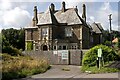
Southlea, Northam
Southlea is a collection of 15 one bedroom retirement bungalows managed by Westward.
In the upper right of this image is a listed building built in the 1870s which was Fairlea Residential Home from 1957 until about 2015.
In 2019 planning permission was given for nine apartments and five houses. There is no evidence of any current activity there.
Image: © Roger A Smith
Taken: 19 Apr 2023
0.01 miles
2
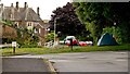
Camping in the suburbs on the corner of Southlea and Cluden Road, Northam
The large property in the left background was once Fairlea Nursing Home
See also: Image
Image: © Roger A Smith
Taken: 10 Jul 2024
0.05 miles
3
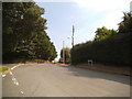
Daddon Hill
The view of the junction with Chope Road near Northam.
Image: © Gordon Griffiths
Taken: 16 Sep 2014
0.06 miles
4
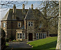
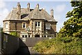
Fairlea, Northam
A grade II listed building.
Fairlea was constructed in the 1870s. The house was occupied by the family of Mr Tom Sawyer, a retired surgeon, and remained with the family until 1902. During the Second World War Fairlea was first used as an orphanage and later as an officers' mess for American forces stationed nearby. It was later used as a council-run retirement home.
Fairlea was acquired by Devon County Council in 1945 for use as a children's home. From 1957 to 2014 the property was used as a residential home for the elderly.
Image: © Roger A Smith
Taken: 14 Feb 2016
0.06 miles
5
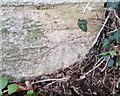
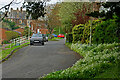
Ordnance Survey Cut Mark
This OS cut mark can be found on the ornate stone post at the junction of Cludon Road. It marks a point 67.937m above mean sea level.
Image: © Adrian Dust
Taken: 14 Feb 2017
0.06 miles
6
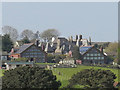
Fairlea Residential Home behind houses on Daddon Hill
Image: © Roger A Smith
Taken: 6 May 2013
0.06 miles