IMAGES TAKEN NEAR TO
College Green, BIDEFORD, EX39 3JY
Introduction
This page details the photographs taken nearby to College Green, EX39 3JY by members of the Geograph project.
The Geograph project started in 2005 with the aim of publishing, organising and preserving representative images for every square kilometre of Great Britain, Ireland and the Isle of Man.

There are currently over 7.5m images from over14,400 individuals and you can help contribute to the project by visiting https://www.geograph.org.uk
Image Map (Loading...)


Getting Data...Please wait
Leaflet Map data © OpenStreetMap
Images are licensed for reuse under creativecommons.org/licenses/by-sa/2.0
Notes
- Clicking on the map will re-center to the selected point.
- The higher the marker number, the further away the image location is from the centre of the postcode.
Image Listing (24 Images Found)
Images are licensed for reuse under creativecommons.org/licenses/by-sa/2.0
Image
Details
Distance
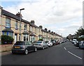
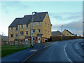
1
Posh housing development on Belvoir Road
Image: © Roger Cornfoot
Taken: 10 Sep 2020
0.06 miles
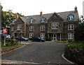
3

Edgehill College and Rugby pitch
Belvoir House, part of Edgehill College and the college Rugby pitch.
Image: © Thor Beverley
Taken: 12 Sep 2003
0.12 miles
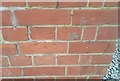
5

Ordnance Survey Cut Mark
This OS cut mark can be found on the wall between Nos104 & 106 Lime Grove. It marks a point 15.575m above mean sea level.
Image: © Adrian Dust
Taken: 6 Dec 2019
0.13 miles
6
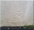
Ordnance Survey Cut Mark
This OS cut mark can be found on No27 Royston Road. It marks a point 50.813m above mean sea level.
Image: © Adrian Dust
Taken: 6 Dec 2019
0.14 miles
7
New townhouses
By the Abbotsham Road, Bideford; viewed from the west towards the town centre.
Image: © Jonathan Billinger
Taken: 16 Jan 2008
0.15 miles
8
Ordnance Survey Cut Mark
This worn OS cut mark can be found on the SW angle of the old school. It marks a point 47.442m above mean sea level.
Image: © Adrian Dust
Taken: 6 Dec 2019
0.16 miles
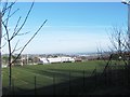
9
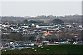
Geneva College and some of Bideford
Geneva College is the red brick building to the right of centre. St Andrew's Church, Alwington is in the top left of the image. The green roofs below the church are on the Cadsdown Industrial Estate.
Image: © Roger A Smith
Taken: 26 Dec 2016
0.16 miles