IMAGES TAKEN NEAR TO
Taylor Crescent, BIDEFORD, EX39 3FA
Introduction
This page details the photographs taken nearby to Taylor Crescent, EX39 3FA by members of the Geograph project.
The Geograph project started in 2005 with the aim of publishing, organising and preserving representative images for every square kilometre of Great Britain, Ireland and the Isle of Man.

There are currently over 7.5m images from over14,400 individuals and you can help contribute to the project by visiting https://www.geograph.org.uk
Image Map
Images are licensed for reuse under creativecommons.org/licenses/by-sa/2.0
Notes
- Clicking on the map will re-center to the selected point.
- The higher the marker number, the further away the image location is from the centre of the postcode.
Image Listing (10 Images Found)
Images are licensed for reuse under creativecommons.org/licenses/by-sa/2.0
Image
Details
Distance
1
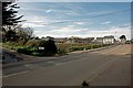
A housing development on Buckleigh Road, Westward Ho!
Image: © Roger A Smith
Taken: 25 Mar 2017
0.02 miles
2
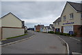
New houses, Westward Ho!
This new road is Taylor Crescent, part of the Deer Park estate. It is not yet on the OS map (at the time of submission).
Image: © Julian P Guffogg
Taken: 19 Jul 2017
0.03 miles
3

A housing development on Buckleigh Road, Westward Ho!
Image: © Roger A Smith
Taken: 25 Mar 2017
0.06 miles
4

Continuing development of Kipling Fields at the end of Crofts Way
The dwellings in the mid ground are those on College Crescent and others either side of Buckleigh Road.
Image: © Roger A Smith
Taken: 24 Sep 2024
0.07 miles
5

Westward Ho! - 1988
Westward Ho!, Buckleigh Road, B3236.
Image: © Helmut Zozmann
Taken: Unknown
0.14 miles
6
Upper Lodge, Fosketh Hill, Westward Ho!
Image: © Roger Cornfoot
Taken: 26 Jul 2012
0.14 miles
7

Westward Ho!-Kingsley Road
Terraced Housing.
Image: © Ian Rob
Taken: 20 May 2021
0.22 miles
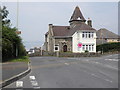
8
The sign says it all
The church was closed that day
Image: © Basher Eyre
Taken: 27 May 2015
0.23 miles

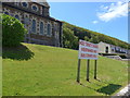
10
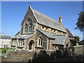
Holy Trinity Church
There is an Ordnance Survey cut mark on the SW angle. http://www.geograph.org.uk/photo/4482685
Image: © Adrian Dust
Taken: 16 May 2015
0.25 miles