IMAGES TAKEN NEAR TO
Limers Lane, BIDEFORD, EX39 2RG
Introduction
This page details the photographs taken nearby to Limers Lane, EX39 2RG by members of the Geograph project.
The Geograph project started in 2005 with the aim of publishing, organising and preserving representative images for every square kilometre of Great Britain, Ireland and the Isle of Man.

There are currently over 7.5m images from over14,400 individuals and you can help contribute to the project by visiting https://www.geograph.org.uk
Image Map (Loading...)


Getting Data...Please wait
Leaflet Map data © OpenStreetMap
Images are licensed for reuse under creativecommons.org/licenses/by-sa/2.0
Notes
- Clicking on the map will re-center to the selected point.
- The higher the marker number, the further away the image location is from the centre of the postcode.
Image Listing (26 Images Found)
Images are licensed for reuse under creativecommons.org/licenses/by-sa/2.0
Image
Details
Distance
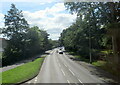
1
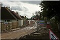
The entrance to a housing development between Limers Lane and the A39
Image: © Roger A Smith
Taken: 20 Feb 2024
0.08 miles
2

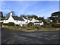
In the centre of this image is a property on Limers Lane, Northam
Image: © Roger A Smith
Taken: 11 Feb 2018
0.12 miles
3
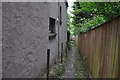
Northam : Footpath
A footpath heading down towards the riverside.
Image: © Lewis Clarke
Taken: 1 Jun 2014
0.15 miles
4
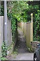
Northam : Durrant Lane
A footpath heading down Durrant Lane.
Image: © Lewis Clarke
Taken: 1 Jun 2014
0.16 miles
5
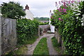
Northam : Footpath
A small footpath heading alongside houses on the Northam outskirts.
Image: © Lewis Clarke
Taken: 1 Jun 2014
0.17 miles
8
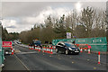
A damaged bridge component at the western end of the Torridge Bridge
See also: Image
Image: © Roger A Smith
Taken: 11 Feb 2018
0.19 miles
9
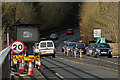
A damaged bridge component at the western end of the Torridge Bridge
Image: © Roger A Smith
Taken: 11 Feb 2018
0.19 miles
