IMAGES TAKEN NEAR TO
Glenburnie Road, BIDEFORD, EX39 2LW
Introduction
This page details the photographs taken nearby to Glenburnie Road, EX39 2LW by members of the Geograph project.
The Geograph project started in 2005 with the aim of publishing, organising and preserving representative images for every square kilometre of Great Britain, Ireland and the Isle of Man.

There are currently over 7.5m images from over14,400 individuals and you can help contribute to the project by visiting https://www.geograph.org.uk
Image Map
Images are licensed for reuse under creativecommons.org/licenses/by-sa/2.0
Notes
- Clicking on the map will re-center to the selected point.
- The higher the marker number, the further away the image location is from the centre of the postcode.
Image Listing (51 Images Found)
Images are licensed for reuse under creativecommons.org/licenses/by-sa/2.0
Image
Details
Distance


3
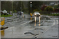
A structural failure in the road surface on Kingsley Road
Image: © Roger A Smith
Taken: 11 Apr 2023
0.08 miles
4
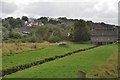
Bideford : Grassy Field
A grassy field with a small stream running through it.
Image: © Lewis Clarke
Taken: 9 Aug 2013
0.08 miles
5
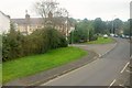
A386 Kingsley Road
Passing Alexandra Terrace north of Bideford.
Image: © Derek Harper
Taken: 27 Sep 2016
0.09 miles
6
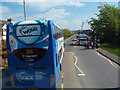
Traffic waits for children to cross Kingsley Road, Bideford
School's out. Photographed from a no.21 bus behind a 21A
Image: © Robin Stott
Taken: 29 Apr 2014
0.11 miles