IMAGES TAKEN NEAR TO
Meddon Street, BIDEFORD, EX39 2EW
Introduction
This page details the photographs taken nearby to Meddon Street, EX39 2EW by members of the Geograph project.
The Geograph project started in 2005 with the aim of publishing, organising and preserving representative images for every square kilometre of Great Britain, Ireland and the Isle of Man.

There are currently over 7.5m images from over14,400 individuals and you can help contribute to the project by visiting https://www.geograph.org.uk
Image Map (Loading...)


Getting Data...Please wait
Leaflet Map data © OpenStreetMap
Images are licensed for reuse under creativecommons.org/licenses/by-sa/2.0
Notes
- Clicking on the map will re-center to the selected point.
- The higher the marker number, the further away the image location is from the centre of the postcode.
Image Listing (245 Images Found)
Images are licensed for reuse under creativecommons.org/licenses/by-sa/2.0
Image
Details
Distance
1
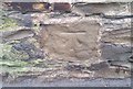
Ordnance Survey Cut Mark
This OS cut mark can be found on the wall of No96 Meddon Street. It marks a point 41.343m above mean sea level.
Image: © Adrian Dust
Taken: 6 Dec 2019
0.01 miles
3

Cemetery, Old Town, Bideford
A very tidy cemetery; the gravestones have all been moved to the edge.
Image: © Humphrey Bolton
Taken: 8 Apr 2010
0.03 miles
4
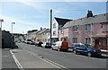
Old Town, Bideford
This is the street name; surprising as one would expect the old town to be where the narrow streets are and near to the church. The fire station is out-of-sight to the left.
Image: © Humphrey Bolton
Taken: 8 Apr 2010
0.03 miles

6
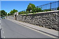
The main entrance to Bideford Public Cemetery on Old Town
Image: © Roger A Smith
Taken: 25 Jun 2010
0.04 miles
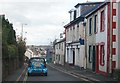
7

Looking down Meddon Street from the junction with Old Town and Clovelly Road
Image: © Roger A Smith
Taken: 25 Jun 2010
0.04 miles
8

The entrance to the Public Cemetery on Old Town
Image: © Roger A Smith
Taken: 25 Jun 2010
0.04 miles
9
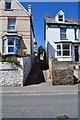
Modell Terrace leading away from Meddon Street
Image: © Roger A Smith
Taken: 25 Jun 2010
0.04 miles
10

Ordnance Survey Cut Mark
This OS cut mark can be found on the wall between Nos126 & 128 Meddon Street. It marks a point 44.928m above mean sea level.
Image: © Adrian Dust
Taken: 6 Dec 2019
0.04 miles