IMAGES TAKEN NEAR TO
Bull Hill, BIDEFORD, EX39 2BH
Introduction
This page details the photographs taken nearby to Bull Hill, EX39 2BH by members of the Geograph project.
The Geograph project started in 2005 with the aim of publishing, organising and preserving representative images for every square kilometre of Great Britain, Ireland and the Isle of Man.

There are currently over 7.5m images from over14,400 individuals and you can help contribute to the project by visiting https://www.geograph.org.uk
Image Map
Images are licensed for reuse under creativecommons.org/licenses/by-sa/2.0
Notes
- Clicking on the map will re-center to the selected point.
- The higher the marker number, the further away the image location is from the centre of the postcode.
Image Listing (593 Images Found)
Images are licensed for reuse under creativecommons.org/licenses/by-sa/2.0
Image
Details
Distance
1

The Torridge, Torridge Hill, Bideford
This listed building was formerly a public house. According to http://www.britishlistedbuildings.co.uk/en-375943-torridge-inn-bideford-devon it ceased to be a public house in 1989. It dates from the early 19th century
Image: © David Smith
Taken: 9 Jun 2014
0.01 miles
2
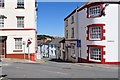
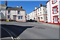
Lower Meddon Street leading away from the junction with Meddon Street and Torridge Hill
Image: © Roger A Smith
Taken: 25 Jun 2010
0.02 miles
3
Meddon Street, and Torridge Hill, Bideford
Image: © Roger Cornfoot
Taken: 26 Jul 2012
0.02 miles
5
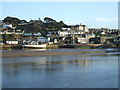
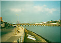
Moored Up
Moored up on the River Torridge in Bideford.
Image: © DI Wyman
Taken: 21 Jan 2007
0.03 miles
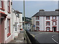
6
Torridge Hill becomes Meddon Street at the junction with Buttgarden Street and Lower Meddon Street
Image: © Roger A Smith
Taken: 25 Jun 2010
0.03 miles
7

Ordnance Survey Cut Mark
This OS cut mark can be found on the wall adjacent to No21 Lower Meddon Street. It marks a point 15.734m above mean sea level.
Image: © Adrian Dust
Taken: 13 Jul 2015
0.03 miles
8

Ordnance Survey Cut Mark
This OS cut mark can be found on the wall north side of Meddon Street. It marks a point 26.902m above mean sea level.
Image: © Adrian Dust
Taken: 5 Dec 2019
0.04 miles
9
New Road, Bideford
This is the A386, bypassing the town centre. It isn't very new, as it is shown on the 1889 1:2500 map.
Image: © Humphrey Bolton
Taken: 5 Mar 2001
0.04 miles
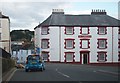
10

Buttgarden Street leading away from the junction with Torridge Hill and Meddon Street
Image: © Roger A Smith
Taken: 25 Jun 2010
0.04 miles