IMAGES TAKEN NEAR TO
Buttgarden Street, BIDEFORD, EX39 2AU
Introduction
This page details the photographs taken nearby to Buttgarden Street, EX39 2AU by members of the Geograph project.
The Geograph project started in 2005 with the aim of publishing, organising and preserving representative images for every square kilometre of Great Britain, Ireland and the Isle of Man.

There are currently over 7.5m images from over14,400 individuals and you can help contribute to the project by visiting https://www.geograph.org.uk
Image Map (Loading...)


Getting Data...Please wait
Leaflet Map data © OpenStreetMap
Images are licensed for reuse under creativecommons.org/licenses/by-sa/2.0
Notes
- Clicking on the map will re-center to the selected point.
- The higher the marker number, the further away the image location is from the centre of the postcode.
Image Listing (667 Images Found)
Images are licensed for reuse under creativecommons.org/licenses/by-sa/2.0
Image
Details
Distance
1
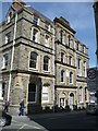
Bridge Buildings, Bridge Street, Bideford
Part of the council offices, opened in 1882. It has a sundial on the wall dated 1692; it was taken from Bridge Hall, which was previously on the site.
Image: © Humphrey Bolton
Taken: 8 Apr 2010
0.00 miles
2
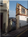
Passage off Buttgarden Street, Bideford
Image: © Robin Stott
Taken: 16 Sep 2014
0.02 miles
3

Ordnance Survey Cut Mark
This OS cut mark can be found on the front of No4 Tower Street.
Image: © Adrian Dust
Taken: 13 Jul 2015
0.02 miles
4

Silver Street, Bideford
Pictured on a very wet morning.
Image: © Jonathan Billinger
Taken: 14 Sep 2015
0.02 miles
5

The door to the Magistrates Room, Bideford Town Hall
Image: © Roger May
Taken: 16 Feb 2011
0.02 miles
6

Junction for Buttergarden Street, Bideford
The 2nd Bideford Scouts meet at the Scout Hall here.
Image: © Eirian Evans
Taken: 24 Nov 2009
0.03 miles

8

Buttgarden Street leading away from the junction with Torridge Hill and Meddon Street
Image: © Roger A Smith
Taken: 25 Jun 2010
0.04 miles
9

Ordnance Survey 1GL Bolt
This OS Bolt can be found on the west face of St Mary's Church. It marks a point 14.996m above mean sea level.
Image: © Adrian Dust
Taken: 13 Jul 2015
0.04 miles
10
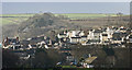
St. Mary's Church is to the left of centre of this image
Victoria Park can be seen at the bottom of the picture.
Image: © Roger A Smith
Taken: 11 Feb 2018
0.04 miles