IMAGES TAKEN NEAR TO
Drake Close, BIDEFORD, EX39 1XA
Introduction
This page details the photographs taken nearby to Drake Close, EX39 1XA by members of the Geograph project.
The Geograph project started in 2005 with the aim of publishing, organising and preserving representative images for every square kilometre of Great Britain, Ireland and the Isle of Man.

There are currently over 7.5m images from over14,400 individuals and you can help contribute to the project by visiting https://www.geograph.org.uk
Image Map
Images are licensed for reuse under creativecommons.org/licenses/by-sa/2.0
Notes
- Clicking on the map will re-center to the selected point.
- The higher the marker number, the further away the image location is from the centre of the postcode.
Image Listing (36 Images Found)
Images are licensed for reuse under creativecommons.org/licenses/by-sa/2.0
Image
Details
Distance
1

Armada Way, off Cornborough Road, Westward Ho!
The area between Cornborough Road and the steep hillside above the coastal strip has been built up with housing estates like this one.
Image: © Humphrey Bolton
Taken: 8 Apr 2010
0.09 miles
2
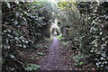
Westward Ho! : Footpath
A footpath heading through the suburbs of Westward Ho!
Image: © Lewis Clarke
Taken: 15 Nov 2014
0.13 miles
3
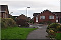
Westward Ho! : Gainsborough Drive
Looking towards a residential street on the Westward Ho! suburbs.
Image: © Lewis Clarke
Taken: 15 Nov 2014
0.15 miles
4
Westward Ho! : Footpath
Looking towards a footpath heading through Westward Ho!
Image: © Lewis Clarke
Taken: 15 Nov 2014
0.16 miles
5

A derelict building in a copse on Kipling Tors
Image: © Roger A Smith
Taken: 24 Mar 2017
0.16 miles
6

Torridge : Pusehill Road
A small road heading into the town of Westward Ho!
Image: © Lewis Clarke
Taken: 15 Nov 2014
0.17 miles
7

Torridge : Pusehill Road
A small road heading between Pusehill and Westward Ho!
Image: © Lewis Clarke
Taken: 15 Nov 2014
0.17 miles
8

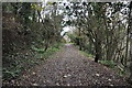
Footpath junction in woods above Westward Ho!
Image: © David Martin
Taken: 16 Sep 2018
0.17 miles
9

Westward Ho!
Chalets and apartment blocks, seen from the footpath along Kipling Tors.
Image: © Humphrey Bolton
Taken: 8 Apr 2010
0.17 miles
10
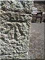
Ordnance Survey Cut Mark
This OS cut mark can be found on the SW angle of Holy Trinity Church. It marks a point 27.344m above mean sea level. http://www.geograph.org.uk/photo/4482688
Image: © Adrian Dust
Taken: 16 May 2015
0.19 miles