IMAGES TAKEN NEAR TO
Fosketh Hill, BIDEFORD, EX39 1UL
Introduction
This page details the photographs taken nearby to Fosketh Hill, EX39 1UL by members of the Geograph project.
The Geograph project started in 2005 with the aim of publishing, organising and preserving representative images for every square kilometre of Great Britain, Ireland and the Isle of Man.

There are currently over 7.5m images from over14,400 individuals and you can help contribute to the project by visiting https://www.geograph.org.uk
Image Map
Images are licensed for reuse under creativecommons.org/licenses/by-sa/2.0
Notes
- Clicking on the map will re-center to the selected point.
- The higher the marker number, the further away the image location is from the centre of the postcode.
Image Listing (99 Images Found)
Images are licensed for reuse under creativecommons.org/licenses/by-sa/2.0
Image
Details
Distance
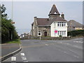
1

Westward Ho!-Kingsley Road
Terraced Housing.
Image: © Ian Rob
Taken: 20 May 2021
0.04 miles
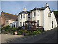
2
Upper Lodge, Fosketh Hill, Westward Ho!
Image: © Roger Cornfoot
Taken: 26 Jul 2012
0.05 miles

4
The Village Inn, Westward Ho!
As well as drink, the Village Inn in Westward Ho! provides meals and bed and breakfast.
Image: © Philip Halling
Taken: 11 Jun 2009
0.08 miles
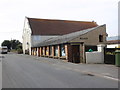
6

Youngaton Road, Westward Ho!
A road that runs down the hill with a view of the sea at the western side of Northam Burrows
Image: © David Smith
Taken: 9 Jun 2014
0.08 miles
8
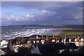
Westward Ho! rooftops on an autumn morning
Image: © Colin Park
Taken: 27 Oct 1994
0.11 miles
9
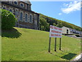
The sign says it all
The church was closed that day
Image: © Basher Eyre
Taken: 27 May 2015
0.11 miles
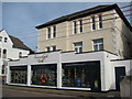
10

A housing development on Buckleigh Road, Westward Ho!
Image: © Roger A Smith
Taken: 25 Mar 2017
0.12 miles