IMAGES TAKEN NEAR TO
Bassetts Close, BIDEFORD, EX39 1SZ
Introduction
This page details the photographs taken nearby to Bassetts Close, EX39 1SZ by members of the Geograph project.
The Geograph project started in 2005 with the aim of publishing, organising and preserving representative images for every square kilometre of Great Britain, Ireland and the Isle of Man.

There are currently over 7.5m images from over14,400 individuals and you can help contribute to the project by visiting https://www.geograph.org.uk
Image Map
Images are licensed for reuse under creativecommons.org/licenses/by-sa/2.0
Notes
- Clicking on the map will re-center to the selected point.
- The higher the marker number, the further away the image location is from the centre of the postcode.
Image Listing (14 Images Found)
Images are licensed for reuse under creativecommons.org/licenses/by-sa/2.0
Image
Details
Distance
1
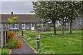
Northam : Burrows Way
Looking along a small path and houses on Burrows Way.
Image: © Lewis Clarke
Taken: 1 Jun 2014
0.16 miles
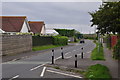
2

Northam : Sandymere Road
Looking along Sandymere Road in the small village of Northam.
Image: © Lewis Clarke
Taken: 1 Jun 2014
0.17 miles
3
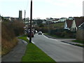
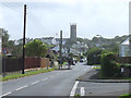
Northam from the north
A good tall church tower presides over an urban sprawl on the north-west Devon coast.
Image: © Jonathan Billinger
Taken: 16 Jan 2008
0.17 miles
4
The end of Golf Links Road, Northam
The view ahead is of the flat Northam Burrows, and the golf course which occupies part of them.
Image: © David Smith
Taken: 9 Jun 2014
0.17 miles
5
Northam : Sandymere Road
Looking along Sandymere Road which heads to Northam Burrows.
Image: © Lewis Clarke
Taken: 1 Jun 2014
0.17 miles
7
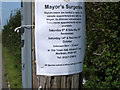
Notice concerning Mayor's Surgeries, Sandymere Road, Northam
Image: © Gary Rogers
Taken: 6 Sep 2017
0.18 miles

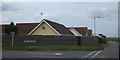
9

Northam : Follyfoot Equestrian Centre
The rear of the equestrian centre.
Image: © Lewis Clarke
Taken: 4 Aug 2023
0.18 miles
10

Old brick structure in field North of Appledore Road
One of several bunkers and other remains of the former WW2 RDF station of RAF Northam, part of the wartime system of radar defence throughout Great Britain known as Chain Home. RAF Northam was operational as an AMES Type 1 station from 1941 to 1944, and the remains are listed Grade II by Historic England.
Thanks to member MikeofDorset for the info.
Image: © Gary Rogers
Taken: 6 Sep 2017
0.19 miles