IMAGES TAKEN NEAR TO
Scott Avenue, BIDEFORD, EX39 1RQ
Introduction
This page details the photographs taken nearby to Scott Avenue, EX39 1RQ by members of the Geograph project.
The Geograph project started in 2005 with the aim of publishing, organising and preserving representative images for every square kilometre of Great Britain, Ireland and the Isle of Man.

There are currently over 7.5m images from over14,400 individuals and you can help contribute to the project by visiting https://www.geograph.org.uk
Image Map
Images are licensed for reuse under creativecommons.org/licenses/by-sa/2.0
Notes
- Clicking on the map will re-center to the selected point.
- The higher the marker number, the further away the image location is from the centre of the postcode.
Image Listing (29 Images Found)
Images are licensed for reuse under creativecommons.org/licenses/by-sa/2.0
Image
Details
Distance
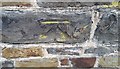
1

Ordnance Survey Cut Mark
This OS cut mark can be found on the wall of No1 Richmond. It marks a point 29.486m above mean sea level.
Image: © Adrian Dust
Taken: 14 Feb 2017
0.06 miles
2

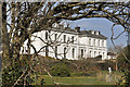
The Holt, Appledore
The narrow link between the two wings makes it look as if it was built as two houses. It is now flats, but was built as a single dwelling for William Yeo, a dock owner, c1850.
Image: © Stephen Richards
Taken: 16 May 2004
0.06 miles
4
Ordnance Survey Cut Mark
This OS cut mark can be found on the wall north side of Richmond Road. It marks a point 39.322m above mean sea level.
Image: © Adrian Dust
Taken: 14 Feb 2017
0.07 miles
5
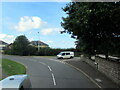
Staddon Road junction with A386 Appledore
Image: © Roy Hughes
Taken: 17 Sep 2022
0.07 miles
6

Ordnance Survey Cut Mark
This OS cut mark can be found on No29 Myrtle Street. It marks a point 17.837m above mean sea level.
Image: © Adrian Dust
Taken: 14 Feb 2017
0.14 miles

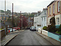
9
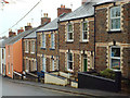
Stepped terraced houses of local stone and two-tone brick, Myrtle Street, Appledore
Myrtle Street is part of the main road into the village.
Image: © Robin Stott
Taken: 29 Apr 2014
0.16 miles
10
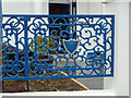
Ornate cast iron fence panel, Odun Road, Appledore
This is the frontage of the Maritime Museum, seen in Image
Image: © Robin Stott
Taken: 29 Apr 2014
0.18 miles