IMAGES TAKEN NEAR TO
Diddywell Road, BIDEFORD, EX39 1NP
Introduction
This page details the photographs taken nearby to Diddywell Road, EX39 1NP by members of the Geograph project.
The Geograph project started in 2005 with the aim of publishing, organising and preserving representative images for every square kilometre of Great Britain, Ireland and the Isle of Man.

There are currently over 7.5m images from over14,400 individuals and you can help contribute to the project by visiting https://www.geograph.org.uk
Image Map
Images are licensed for reuse under creativecommons.org/licenses/by-sa/2.0
Notes
- Clicking on the map will re-center to the selected point.
- The higher the marker number, the further away the image location is from the centre of the postcode.
Image Listing (16 Images Found)
Images are licensed for reuse under creativecommons.org/licenses/by-sa/2.0
Image
Details
Distance
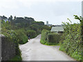

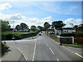
3
Crossroads in Appledore
A crossroads just outside Appledore.
Image: © Philip Halling
Taken: 11 Jun 2009
0.17 miles
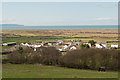
5

A386 in Diddywell
Partway between Appledore and Northam, Diddywell is a small cluster of houses at a crossroads
Image: © David Smith
Taken: 9 Jun 2014
0.18 miles
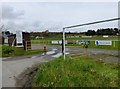
6

Junction of Burrows Lane and Long Lane, Assells
Image: © Gary Rogers
Taken: 6 Sep 2017
0.19 miles
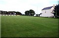
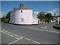
7
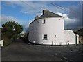
House, at corner of Long Lane and Broad Lane
Image: © Roger Cornfoot
Taken: 22 Nov 2014
0.19 miles