IMAGES TAKEN NEAR TO
Jackets Lane, BIDEFORD, EX39 1HT
Introduction
This page details the photographs taken nearby to Jackets Lane, EX39 1HT by members of the Geograph project.
The Geograph project started in 2005 with the aim of publishing, organising and preserving representative images for every square kilometre of Great Britain, Ireland and the Isle of Man.

There are currently over 7.5m images from over14,400 individuals and you can help contribute to the project by visiting https://www.geograph.org.uk
Image Map
Images are licensed for reuse under creativecommons.org/licenses/by-sa/2.0
Notes
- Clicking on the map will re-center to the selected point.
- The higher the marker number, the further away the image location is from the centre of the postcode.
Image Listing (82 Images Found)
Images are licensed for reuse under creativecommons.org/licenses/by-sa/2.0
Image
Details
Distance
1
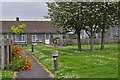
Northam : Burrows Way
Looking along a small path and houses on Burrows Way.
Image: © Lewis Clarke
Taken: 1 Jun 2014
0.07 miles
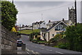
3
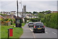
Northam : Sandymere Road
Looking along Sandymere Road in the small village of Northam.
Image: © Lewis Clarke
Taken: 1 Jun 2014
0.08 miles
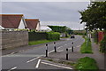
4
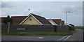
The end of Golf Links Road, Northam
The view ahead is of the flat Northam Burrows, and the golf course which occupies part of them.
Image: © David Smith
Taken: 9 Jun 2014
0.09 miles
5
Northam : Sandymere Road
Looking along Sandymere Road as it heads up the hill.
Image: © Lewis Clarke
Taken: 1 Jun 2014
0.10 miles
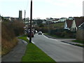
6
Northam : Sandymere Road
Looking along Sandymere Road which heads to Northam Burrows.
Image: © Lewis Clarke
Taken: 1 Jun 2014
0.11 miles
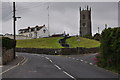
7
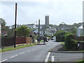
Northam from the north
A good tall church tower presides over an urban sprawl on the north-west Devon coast.
Image: © Jonathan Billinger
Taken: 16 Jan 2008
0.11 miles
8
Northam : Sandymere Road
Looking along Sandymere Road as it heads through Northam.
Image: © Lewis Clarke
Taken: 1 Jun 2014
0.15 miles
9

Northam : Sandymere Road
Looking along Sandymere Road as it heads through Northam.
Image: © Lewis Clarke
Taken: 1 Jun 2014
0.15 miles
10
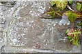
Ordnance Survey Cut Mark
This OS cut mark can be found on the wall of Clover Bank, Sandymere Road. It marks a point 32.227m above mean sea level.
Image: © Adrian Dust
Taken: 14 Feb 2017
0.15 miles