IMAGES TAKEN NEAR TO
Beresford Drive, EX39 1FW
Introduction
This page details the photographs taken nearby to Beresford Drive, EX39 1FW by members of the Geograph project.
The Geograph project started in 2005 with the aim of publishing, organising and preserving representative images for every square kilometre of Great Britain, Ireland and the Isle of Man.

There are currently over 7.5m images from over14,400 individuals and you can help contribute to the project by visiting https://www.geograph.org.uk
Image Map
Images are licensed for reuse under creativecommons.org/licenses/by-sa/2.0
Notes
- Clicking on the map will re-center to the selected point.
- The higher the marker number, the further away the image location is from the centre of the postcode.
Image Listing (6 Images Found)
Images are licensed for reuse under creativecommons.org/licenses/by-sa/2.0
Image
Details
Distance
1
New homes on Kipling Fields and a Mast on Bay View Road
Image: © Roger A Smith
Taken: 23 Sep 2023
0.08 miles
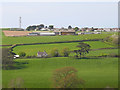
2
The mast on Bay View Road and a housing development known as Kipling Fields
Image: © Roger A Smith
Taken: 20 Aug 2024
0.11 miles
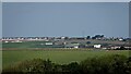
3
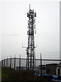
Westward Ho! TV-Relay tower
On a hill within the grounds of an underground reservoir stands this small tower belonging to Arqiva, it is a TV-Relay for the area around Westward Ho!
It is a dependent relay from Huntshaw Cross near to Great Torrington.
Image: © David Neale
Taken: 7 Dec 2005
0.11 miles
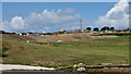
4
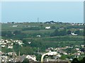
The Mast on Bay View Road, Northam with Bideford in the lower foreground
Image: © Roger A Smith
Taken: 3 Jun 2008
0.12 miles