IMAGES TAKEN NEAR TO
Town Meadow, TORRINGTON, EX38 8RD
Introduction
This page details the photographs taken nearby to Town Meadow, EX38 8RD by members of the Geograph project.
The Geograph project started in 2005 with the aim of publishing, organising and preserving representative images for every square kilometre of Great Britain, Ireland and the Isle of Man.

There are currently over 7.5m images from over14,400 individuals and you can help contribute to the project by visiting https://www.geograph.org.uk
Image Map
Images are licensed for reuse under creativecommons.org/licenses/by-sa/2.0
Notes
- Clicking on the map will re-center to the selected point.
- The higher the marker number, the further away the image location is from the centre of the postcode.
Image Listing (5 Images Found)
Images are licensed for reuse under creativecommons.org/licenses/by-sa/2.0
Image
Details
Distance
1
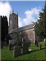
St Giles church, Little Torrington
Hoskins considers this a dull church. It has been substantially rebuilt, but it makes a pleasant sight in a sloping churchyard in this small village.
Image: © Derek Harper
Taken: 30 Oct 2007
0.06 miles

3
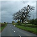
Fork here for Little Torrington
The A386 by-passes the village; this is one road into the centre from the south
Image: © David Smith
Taken: 9 May 2013
0.17 miles
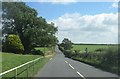
5
Junction outside Little Torrington
The A386 passes to the west of the village, and the road opposite the photographer at this crossroads leads to the village centre
Image: © David Smith
Taken: 23 Jan 2015
0.21 miles