IMAGES TAKEN NEAR TO
Langtree, TORRINGTON, EX38 8NY
Introduction
This page details the photographs taken nearby to EX38 8NY by members of the Geograph project.
The Geograph project started in 2005 with the aim of publishing, organising and preserving representative images for every square kilometre of Great Britain, Ireland and the Isle of Man.

There are currently over 7.5m images from over14,400 individuals and you can help contribute to the project by visiting https://www.geograph.org.uk
Image Map
Images are licensed for reuse under creativecommons.org/licenses/by-sa/2.0
Notes
- Clicking on the map will re-center to the selected point.
- The higher the marker number, the further away the image location is from the centre of the postcode.
Image Listing (3 Images Found)
Images are licensed for reuse under creativecommons.org/licenses/by-sa/2.0
Image
Details
Distance
1
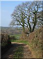
Green lane at Little Comfort
The green lane descends round a bend beneath trees on its way to the scene in Image Beyond is the Langtree Lake valley.
Image: © Derek Harper
Taken: 16 Feb 2008
0.12 miles
2
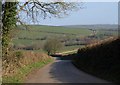
Lane to Little Comfort
Little Comfort is the farm along the track which leads off to the right behind the hedge. The lane, which has come from Sandylane Cross, plunges down towards the Langtree Lake valley, which is off to the left.
Seen from close to the point where Image was taken, looking across to the left of this scene.
Image: © Derek Harper
Taken: 16 Feb 2008
0.14 miles
3
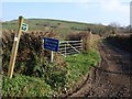
Green lane at Little Comfort
The track leaves the lane from Watergate Bridge to Sandylane Cross and cuts across a ridge to the valley followed by the Tarka Trail a kilometre to the east. Another green lane following the ridge runs across the hill on the left to Gortlage.
Image: © Derek Harper
Taken: 16 Feb 2008
0.15 miles