IMAGES TAKEN NEAR TO
Langtree, TORRINGTON, EX38 8NX
Introduction
This page details the photographs taken nearby to EX38 8NX by members of the Geograph project.
The Geograph project started in 2005 with the aim of publishing, organising and preserving representative images for every square kilometre of Great Britain, Ireland and the Isle of Man.

There are currently over 7.5m images from over14,400 individuals and you can help contribute to the project by visiting https://www.geograph.org.uk
Image Map (Loading...)


Getting Data...Please wait
Leaflet Map data © OpenStreetMap
Images are licensed for reuse under creativecommons.org/licenses/by-sa/2.0
Notes
- Clicking on the map will re-center to the selected point.
- The higher the marker number, the further away the image location is from the centre of the postcode.
Image Listing (3 Images Found)
Images are licensed for reuse under creativecommons.org/licenses/by-sa/2.0
Image
Details
Distance
1
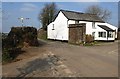
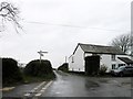
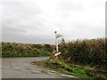
Sandylane Cross
The maps have "Sandylane Cross" but the signpost has "Sandlane Cross". Normally I'm with the signposts, but on this occasion I'm inclined to side with the maps. The cottage is between the lanes to Watergate Bridge (left) and Langtree Week (right). The lane behind the camera is from Berry Cross.
Image: © Derek Harper
Taken: 16 Feb 2008
0.01 miles