IMAGES TAKEN NEAR TO
Warren Lane, TORRINGTON, EX38 8AZ
Introduction
This page details the photographs taken nearby to Warren Lane, EX38 8AZ by members of the Geograph project.
The Geograph project started in 2005 with the aim of publishing, organising and preserving representative images for every square kilometre of Great Britain, Ireland and the Isle of Man.

There are currently over 7.5m images from over14,400 individuals and you can help contribute to the project by visiting https://www.geograph.org.uk
Image Map
Images are licensed for reuse under creativecommons.org/licenses/by-sa/2.0
Notes
- Clicking on the map will re-center to the selected point.
- The higher the marker number, the further away the image location is from the centre of the postcode.
Image Listing (171 Images Found)
Images are licensed for reuse under creativecommons.org/licenses/by-sa/2.0
Image
Details
Distance
1
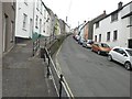
Looking up Mill Street
It's a real puff to the top on foot!
Image: © John Baker
Taken: 25 Mar 2013
0.04 miles
2

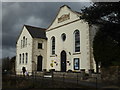
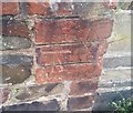
Ordnance Survey Cut Mark
This OS cut mark can be found on the south face of the Methodist Chapel. It marks a point 103.998m above mean sea level.
Image: © Adrian Dust
Taken: 18 Oct 2015
0.05 miles


6

The top of Mill Street
Looking along South Street, with White's Lane to the left.
Image: © John Baker
Taken: 25 Mar 2013
0.08 miles
7

Church Lane Great Torrington
According to the Post Office ''Church Lane'' is the commonest street name in the UK.
Image: © Dr Duncan Pepper
Taken: 18 Jul 2008
0.09 miles
8
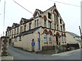
Great Torrington - Vaughan's Glove Factory
Now closed, this amazing confection was built in 1884 and remained in use until recently. Pevsner described it as the oddest building in town and the architecture is more ecclesiastical than industrial.
Image: © Chris Allen
Taken: 21 Apr 2013
0.10 miles
9
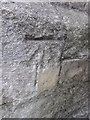
Ordnance Survey Cut Mark
This OS cut mark can be found on No77 New Street. It marks a point 104.885m above mean sea level.
Image: © Adrian Dust
Taken: 18 Oct 2015
0.10 miles
10
Ordnance Survey Cut Mark
This OS cut mark can be found on the wall post of No30 Mill Street. It marks a point 68.540m above mean sea level.
Image: © Adrian Dust
Taken: 5 Dec 2019
0.10 miles