IMAGES TAKEN NEAR TO
Rolle Road, TORRINGTON, EX38 8AU
Introduction
This page details the photographs taken nearby to Rolle Road, EX38 8AU by members of the Geograph project.
The Geograph project started in 2005 with the aim of publishing, organising and preserving representative images for every square kilometre of Great Britain, Ireland and the Isle of Man.

There are currently over 7.5m images from over14,400 individuals and you can help contribute to the project by visiting https://www.geograph.org.uk
Image Map
Images are licensed for reuse under creativecommons.org/licenses/by-sa/2.0
Notes
- Clicking on the map will re-center to the selected point.
- The higher the marker number, the further away the image location is from the centre of the postcode.
Image Listing (44 Images Found)
Images are licensed for reuse under creativecommons.org/licenses/by-sa/2.0
Image
Details
Distance
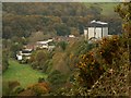
1
Another view of the old Dairy Crest Creamery on Limer's Hill
Image: © Roger A Smith
Taken: 27 Oct 2009
0.10 miles
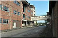
2
The old Dairy Crest Creamery
http://www.28dayslater.co.uk/forums/showthread.php?t=35693
Image: © Roger A Smith
Taken: 27 Oct 2009
0.10 miles
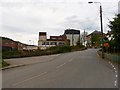
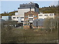
3
Former creamery - Great Torrington
The creamery was founded in 1874 and was significantly expanded after the Second World War. It was latterly operated by Dairy Crest and closed in 1993 following a fire.
Image: © Chris Allen
Taken: 3 Apr 2018
0.11 miles
6
Former Dairy Crest creamery
A detail of the derelict creamery at Torrington. The original factory buildings contain a number of art deco features as illustrated by the design of the footbridge that linked to the canteen.
Image: © Noel Jenkins
Taken: 19 Sep 2009
0.13 miles
7
Former Dairy Crest Factory, Great Torrington
Image: © Roger Cornfoot
Taken: 9 Mar 2009
0.13 miles
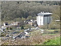
8
Former Dairy Crest/M&D Transport site
The site in question is the building behind the silver car and was the site of the Rolle Canal Company’s stores that was leased to Messrs Robert Sandford & Son and then in 1874 became the Torridge Vale Butter Factory, later to become the much expanded, highly mechanised Milk Marketing Board's Dairy Crest Plant, which closed in 1993 http://www.great-torrington.com/history/
I saw, while scouting around the entrance to the building for clues after taking my photograph, signage for M&D Transport. I found two links for the company http://archive.commercialmotor.com/article/27th-july-2000/40/md-transport and this explained that in the year 2000, M&D Transport was an ongoing concern specialising in the running of a fleet of reefers (slang for refrigerated railway cars (in this context lorries)) and bulk tippers (lorries or trucks) to transport animal carcases from the abattoirs in and around Great Torrington to London’s Smithfield Market and regional distribution centres across the south of England. Eggs and cheese were also collected from farms in Devon and Cornwall. I sent an email to the company http://mdtransport.co.uk but did not receive a reply, which may be because the website is under construction.
Then I wrote to Great Torrington Tourist Information Centre and am indebted to Penny Podmore, the manager of the centre for her reply “M&D Transport really just used the Old Dairy site as store and parking site for their lorries and I think they only left there within the last year or two. I think they are now on the Hatchmoor Industrial Estate”.
Image: © John Baker
Taken: 25 Mar 2013
0.13 miles
9
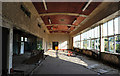
Old creamery canteen
The sumptuous dining area for workers at the creamery with views across the Torridge valley
Image: © Noel Jenkins
Taken: 19 Sep 2009
0.14 miles
10
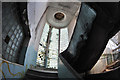
Stairwell inside the former creamery
The stairwell is a superb art deco feature of the now derelict creamery.
Image: © Noel Jenkins
Taken: 19 Sep 2009
0.14 miles