IMAGES TAKEN NEAR TO
Bluecoat Villas, TORRINGTON, EX38 8AP
Introduction
This page details the photographs taken nearby to Bluecoat Villas, EX38 8AP by members of the Geograph project.
The Geograph project started in 2005 with the aim of publishing, organising and preserving representative images for every square kilometre of Great Britain, Ireland and the Isle of Man.

There are currently over 7.5m images from over14,400 individuals and you can help contribute to the project by visiting https://www.geograph.org.uk
Image Map
Images are licensed for reuse under creativecommons.org/licenses/by-sa/2.0
Notes
- Clicking on the map will re-center to the selected point.
- The higher the marker number, the further away the image location is from the centre of the postcode.
Image Listing (192 Images Found)
Images are licensed for reuse under creativecommons.org/licenses/by-sa/2.0
Image
Details
Distance
1

Palmer House 1752
Palmer House, which is Grade II* listed, was built in 1752 by John (later Sir) Palmer, who was three times Mayor of Great Torrington, and brother-in-law to the famous artist Sir Joshua Reynolds. Palmer House is unique in that unlike many Georgian properties from this period it retains many original features, which include fine ornate plaster ceilings, original marble and carved fireplaces, original mahogany doors and fine balustraded staircase. The house remained in the ownership of the Palmer family until the 1890's. During that time many famous people visited and stayed at the house. These include Dr. Samuel Johnson, who along with his friend Sir Joshua Reynolds, stayed at the house in 1762, Admiral Lord Horatio Nelson, who had relatives in this area is also known to have visited Palmer House.
Image: © Patricia Barnes
Taken: 23 Apr 2011
0.03 miles
2
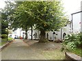
Gothic cottages alongside St Michael's church, Great Torrington
The cobbled mound in the picture is reputed to be the mass grave of the Roundhead's captured prisoners who, during the English Civil War, were temporarily locked in the church when barrels of gunpowder stored there somehow exploded, with great loss of life
Image: © Derek Voller
Taken: 16 Sep 2015
0.03 miles
3
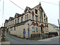
Great Torrington - Vaughan's Glove Factory
Now closed, this amazing confection was built in 1884 and remained in use until recently. Pevsner described it as the oddest building in town and the architecture is more ecclesiastical than industrial.
Image: © Chris Allen
Taken: 21 Apr 2013
0.03 miles
4

Church Lane Great Torrington
According to the Post Office ''Church Lane'' is the commonest street name in the UK.
Image: © Dr Duncan Pepper
Taken: 18 Jul 2008
0.04 miles
5
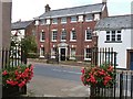
Elegant Georgian house on New Street (the A386), Great Torrington, Devon
Taken from the colourful gateway of St Michael and All Angels church
Image: © Derek Voller
Taken: 16 Sep 2015
0.04 miles
6

Memorial cross, Great Torrington
A rather grand Celtic memorial cross in the churchyard of St Michael and All Angels' church in Great Torrington.
Image: © Philip Halling
Taken: 11 Apr 2015
0.04 miles
7
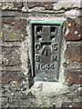
Ordnance Survey Flush Bracket (1644)
This OS Flush Bracket can be found on the NW angle of the tower of St Michael & All Angel's Church. It marks a point 103.708m above mean sea level.
Image: © Adrian Dust
Taken: 21 Apr 2015
0.05 miles
8
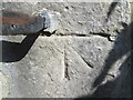
Ordnance Survey 1GL Bolt
This OS Bolt can be found on the SW angle of the tower of St Michael & All Angel's Church. It marks a point 103.818m above mean sea level.
Image: © Adrian Dust
Taken: 21 Apr 2015
0.05 miles
9

Ordnance Survey Flush Bracket (1851)
This OS Flush Bracket can be found on the NW angle of St Michael & All Angels Church. It marks a point 103.708m above mean sea level.
Image: © Adrian Dust
Taken: 18 Oct 2015
0.05 miles
10

A stained glass window in the tower of the church of St Michael & All Angels, Torrington
Image: © Roger A Smith
Taken: 15 Jan 2020
0.05 miles