IMAGES TAKEN NEAR TO
Kingscott, TORRINGTON, EX38 7JW
Introduction
This page details the photographs taken nearby to EX38 7JW by members of the Geograph project.
The Geograph project started in 2005 with the aim of publishing, organising and preserving representative images for every square kilometre of Great Britain, Ireland and the Isle of Man.

There are currently over 7.5m images from over14,400 individuals and you can help contribute to the project by visiting https://www.geograph.org.uk
Image Map
Images are licensed for reuse under creativecommons.org/licenses/by-sa/2.0
Notes
- Clicking on the map will re-center to the selected point.
- The higher the marker number, the further away the image location is from the centre of the postcode.
Image Listing (7 Images Found)
Images are licensed for reuse under creativecommons.org/licenses/by-sa/2.0
Image
Details
Distance
1
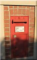
Victorian postbox, Kingscott
Image: © Derek Harper
Taken: 30 Nov 2016
0.07 miles
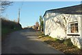
2
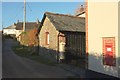
Kingscott Hill
On the right is the wall of Strawberry Cottage, shown in Image], with Victorian postbox EX38 50. The next thatched cottage is Biskey How, also listed https://www.historicengland.org.uk/listing/the-list/list-entry/1147806 .
Image: © Derek Harper
Taken: 30 Nov 2016
0.08 miles
3

Sheep, Kingscott
Looking left from where Image was taken, towards the valley below St Giles in the Wood. Still frost in the foreground shadow.
Image: © Derek Harper
Taken: 30 Nov 2016
0.09 miles
4
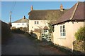
Cottages, Kingscott
The thatched cottage, Biskey How, is listed and described at https://www.historicengland.org.uk/listing/the-list/list-entry/1147806 .
Image: © Derek Harper
Taken: 30 Nov 2016
0.09 miles
5
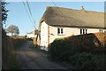
Kingscott Hill
A very high contrast between the sunny walls and the dark lane makes this image problematic. The thatched Strawberry Cottage is "probably C18 ... the left (south-west) end room is end onto the lane ... Older people in the parish remember this room being used as a shop" https://www.historicengland.org.uk/listing/the-list/list-entry/1104982 . Victorian postbox EX38 50 can be seen in the wall; see also Image
Image: © Derek Harper
Taken: 30 Nov 2016
0.11 miles
6
Kingscott Hill
Approaching the top of the hill, where the lane reaches a T junction.
Image: © Derek Harper
Taken: 30 Nov 2016
0.13 miles
7

Farmland, Kingscott
Image: © Derek Harper
Taken: 30 Nov 2016
0.20 miles