
IMAGES TAKEN NEAR TO
Calf Street, TORRINGTON, EX38 7BG
Introduction
This page details the photographs taken nearby to Calf Street, EX38 7BG by members of the Geograph project.
The Geograph project started in 2005 with the aim of publishing, organising and preserving representative images for every square kilometre of Great Britain, Ireland and the Isle of Man.

There are currently over 7.5m images from over14,400 individuals and you can help contribute to the project by visiting https://www.geograph.org.uk
Image Map
Images are licensed for reuse under creativecommons.org/licenses/by-sa/2.0
Notes
- Clicking on the map will re-center to the selected point.
- The higher the marker number, the further away the image location is from the centre of the postcode.
Image Listing (155 Images Found)
Images are licensed for reuse under creativecommons.org/licenses/by-sa/2.0
Image
Details
Distance

2
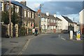
Calf Street - B3227
Road to Barnstaple leading out of Great Torrington.
Image: © Fernweh
Taken: 28 Oct 2015
0.04 miles
3
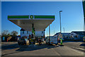
Great Torrington : BP Petrol Station
The petrol station also has a M&S Simply Food.
Image: © Lewis Clarke
Taken: 4 Dec 2019
0.05 miles
4

Garage and Budgens shop at the junction of the A3124 and the A386
Image: © Rob Purvis
Taken: 26 Apr 2014
0.06 miles

6

Torrington Fire Station
Torrington Fire Station, Calf Street, Torrington, Devon. If you have trouble finding Torrington in a map gazetteer, it is also known as Great Torrington.
Image: © Kevin Hale
Taken: 1 Jul 1990
0.06 miles
7
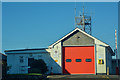
Great Torrington : Torrington Community Fire Station
Torrington Fire Station is a retained station with 1 Watch Manager, 2 Crew Managers and 9 Firefighters. The station houses one firefighting appliance.
Image: © Lewis Clarke
Taken: 4 Dec 2019
0.06 miles
8
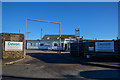
Great Torrington : Devon Highways Depot
Purpose Highways and bridges depot on Gas Lane.
Image: © Lewis Clarke
Taken: 4 Dec 2019
0.07 miles
9

Junction of the A3124 (going left) and the A386 from the garage at that junction
Image: © Rob Purvis
Taken: 26 Apr 2014
0.07 miles
10

Ordnance Survey Cut Mark
This OS cut mark can be found on No51 Well Street. It marks a point 93.400m above mean sea level.
Image: © Adrian Dust
Taken: 18 Oct 2015
0.08 miles