IMAGES TAKEN NEAR TO
Chittlehampton, UMBERLEIGH, EX37 9QT
Introduction
This page details the photographs taken nearby to EX37 9QT by members of the Geograph project.
The Geograph project started in 2005 with the aim of publishing, organising and preserving representative images for every square kilometre of Great Britain, Ireland and the Isle of Man.

There are currently over 7.5m images from over14,400 individuals and you can help contribute to the project by visiting https://www.geograph.org.uk
Image Map
Images are licensed for reuse under creativecommons.org/licenses/by-sa/2.0
Notes
- Clicking on the map will re-center to the selected point.
- The higher the marker number, the further away the image location is from the centre of the postcode.
Image Listing (2 Images Found)
Images are licensed for reuse under creativecommons.org/licenses/by-sa/2.0
Image
Details
Distance
1
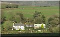
Colleytown House
The farmhouse on the left, seen here from the same spot as Image] of which this is a detail, is listed and described (as "Collytown Farmhouse") at https://www.historicengland.org.uk/listing/the-list/list-entry/1079493 . "Early to mid C18".
Image: © Derek Harper
Taken: 8 Feb 2017
0.03 miles
2
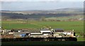
South Newton
A detail of the scene in Image On the right is the white listed farmhouse described at https://www.historicengland.org.uk/listing/the-list/list-entry/1258182 . "C16/C17 with possibly earlier origins". The barn, which is included in the same description, is to the left of the farmhouse and has a dark roof.
Image: © Derek Harper
Taken: 8 Feb 2017
0.15 miles