IMAGES TAKEN NEAR TO
Chittlehampton, UMBERLEIGH, EX37 9QH
Introduction
This page details the photographs taken nearby to EX37 9QH by members of the Geograph project.
The Geograph project started in 2005 with the aim of publishing, organising and preserving representative images for every square kilometre of Great Britain, Ireland and the Isle of Man.

There are currently over 7.5m images from over14,400 individuals and you can help contribute to the project by visiting https://www.geograph.org.uk
Image Map (Loading...)


Getting Data...Please wait
Leaflet Map data © OpenStreetMap
Images are licensed for reuse under creativecommons.org/licenses/by-sa/2.0
Notes
- Clicking on the map will re-center to the selected point.
- The higher the marker number, the further away the image location is from the centre of the postcode.
Image Listing (94 Images Found)
Images are licensed for reuse under creativecommons.org/licenses/by-sa/2.0
Image
Details
Distance
2

Chittlehampton panorama
Panoramic view of Chittlehampton.
Image: © Alan Hughes
Taken: 13 Apr 2018
0.08 miles
4
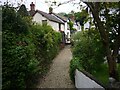
Path leading to St Urith's Well
https://historicengland.org.uk/listing/the-list/list-entry/1392218?section=official-list-entry
Image: © Sandy Gerrard
Taken: Unknown
0.08 miles
5
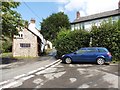
Chittlehampton : East Street
Looking along a road through the village.
Image: © Lewis Clarke
Taken: 22 Dec 2016
0.09 miles
6
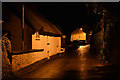
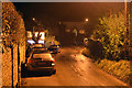
Chittlehampton : East Street
Looking along a road.
Image: © Lewis Clarke
Taken: 22 Dec 2016
0.10 miles
7
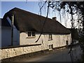
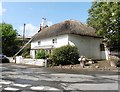
Thatched cottage
Thatched cottage in Chittlehampton.
Image: © Alan Hughes
Taken: 14 Apr 2018
0.10 miles


10
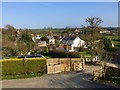
The village of Chittlehampton
Evening sunlight on the village of Chittlehampton.
Image: © Alan Hughes
Taken: 14 Apr 2018
0.14 miles