IMAGES TAKEN NEAR TO
Burrington, UMBERLEIGH, EX37 9LH
Introduction
This page details the photographs taken nearby to EX37 9LH by members of the Geograph project.
The Geograph project started in 2005 with the aim of publishing, organising and preserving representative images for every square kilometre of Great Britain, Ireland and the Isle of Man.

There are currently over 7.5m images from over14,400 individuals and you can help contribute to the project by visiting https://www.geograph.org.uk
Image Map
Images are licensed for reuse under creativecommons.org/licenses/by-sa/2.0
Notes
- Clicking on the map will re-center to the selected point.
- The higher the marker number, the further away the image location is from the centre of the postcode.
Image Listing (4 Images Found)
Images are licensed for reuse under creativecommons.org/licenses/by-sa/2.0
Image
Details
Distance
2
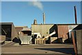
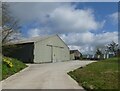
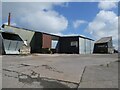
Aylescott Feeds & Driers
Industry in the countryside: this plant west of Aylescott was described in the 1980s as follows: it "processes fresh cut grass into pellets for animal feed. Grass is brought to the pad where it is conveyed into a tumble drier for about a minute. Then it is milled into a powder which is compressed into grass pellets" http://www.bbc.co.uk/history/domesday/dblock/GB-260000-114000/page/3 . It's quite likely that details may have changed over 30 years.
Image: © Derek Harper
Taken: 30 Nov 2016
0.08 miles
3
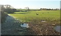
Sheep near West Aylescott
On the other side of the lane from Image
Image: © Derek Harper
Taken: 30 Nov 2016
0.10 miles