IMAGES TAKEN NEAR TO
Burrington, UMBERLEIGH, EX37 9LD
Introduction
This page details the photographs taken nearby to EX37 9LD by members of the Geograph project.
The Geograph project started in 2005 with the aim of publishing, organising and preserving representative images for every square kilometre of Great Britain, Ireland and the Isle of Man.

There are currently over 7.5m images from over14,400 individuals and you can help contribute to the project by visiting https://www.geograph.org.uk
Image Map
Images are licensed for reuse under creativecommons.org/licenses/by-sa/2.0
Notes
- Clicking on the map will re-center to the selected point.
- The higher the marker number, the further away the image location is from the centre of the postcode.
Image Listing (4 Images Found)
Images are licensed for reuse under creativecommons.org/licenses/by-sa/2.0
Image
Details
Distance

2

Near Northcote Cross
Horses graze in a field near Bryher Cottage alongside the lane from Red Post to Northcote Cross. The farm on the left is Handford.
Image: © Derek Harper
Taken: 13 Sep 2007
0.15 miles
3
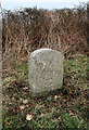
Old Milestone east of Northcote Cross, Burrington
Carved stone post by the UC road, in parish of Burrington (North Devon District), 250m East of Northcote Cross, opposite lay-by, on grass verge, under brambles, by telegraph pole, on North side of road. Barum tombstone, erected by the Barnstaple turnpike trust in the 19th century.
Inscription reads:-
12
BARUM
Carved benchmark on lower face.
Devon & Dartmoor HER.
HER Number: MDV34887 https://www.heritagegateway.org.uk/Gateway/Results_Single.aspx?uid=MDV34887&resourceID=104
Milestone Society National ID: DV_BSLC12
Image: © Alan Rosevear
Taken: 13 Feb 2012
0.18 miles
4

Field near Northcote Cross
A view through a gateway of a field beside the lane from Red Post Cross to Northcote Cross. The trees on the horizon are in SS6218.
Image: © Derek Harper
Taken: 13 Sep 2007
0.20 miles