IMAGES TAKEN NEAR TO
Chittlehamholt, UMBERLEIGH, EX37 9HF
Introduction
This page details the photographs taken nearby to EX37 9HF by members of the Geograph project.
The Geograph project started in 2005 with the aim of publishing, organising and preserving representative images for every square kilometre of Great Britain, Ireland and the Isle of Man.

There are currently over 7.5m images from over14,400 individuals and you can help contribute to the project by visiting https://www.geograph.org.uk
Image Map
Images are licensed for reuse under creativecommons.org/licenses/by-sa/2.0
Notes
- Clicking on the map will re-center to the selected point.
- The higher the marker number, the further away the image location is from the centre of the postcode.
Image Listing (11 Images Found)
Images are licensed for reuse under creativecommons.org/licenses/by-sa/2.0
Image
Details
Distance
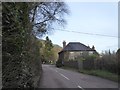
1
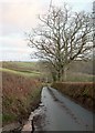
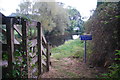
Lane to the Taw valley
The lane from Hayne Town Cross drops ever more steeply.
Image: © Derek Harper
Taken: 8 Feb 2017
0.11 miles
2
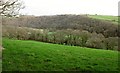
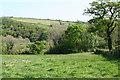
Taw valley
From the lane shown in Image], looking right. Across the valley are Bias Wood (left) and the contiguous Yeotown Wood. Pale on the valley floor are polytunnels at Lower Watertown. It's almost a night scene, at 8 minutes past five.
Image: © Derek Harper
Taken: 8 Feb 2017
0.13 miles
7
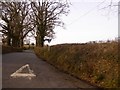
Farmland above the Taw valley
Looking left from where Image] was taken, across a side valley above the Taw. The lack of light on the ground is explained by the pink clouds which signal sunset.
Image: © Derek Harper
Taken: 8 Feb 2017
0.15 miles
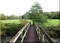
8
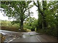
Mole Cottage by B3226
This riverside house marks the former ford (Yeotown Ford) through the river Image where there is still a footbridge. The late Victorian map marks a hotel at this site
Image: © David Smith
Taken: 16 Feb 2018
0.16 miles
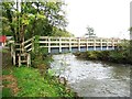
9
Former Ford at Chittlehamholt
This is the site of a former ford on the River Mole beside Mole Cottage at Chittlehamholt.
Image: © John Walton
Taken: 23 Sep 2014
0.16 miles
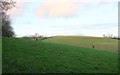
10
Satterleigh and Warkleigh: above the Mole valley
Looking south-south-east
Image: © Martin Bodman
Taken: 1 May 2007
0.17 miles