IMAGES TAKEN NEAR TO
Warkleigh, UMBERLEIGH, EX37 9DN
Introduction
This page details the photographs taken nearby to EX37 9DN by members of the Geograph project.
The Geograph project started in 2005 with the aim of publishing, organising and preserving representative images for every square kilometre of Great Britain, Ireland and the Isle of Man.

There are currently over 7.5m images from over14,400 individuals and you can help contribute to the project by visiting https://www.geograph.org.uk
Image Map
Images are licensed for reuse under creativecommons.org/licenses/by-sa/2.0
Notes
- Clicking on the map will re-center to the selected point.
- The higher the marker number, the further away the image location is from the centre of the postcode.
Image Listing (3 Images Found)
Images are licensed for reuse under creativecommons.org/licenses/by-sa/2.0
Image
Details
Distance
1
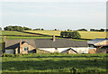
Pugsley Farm
The Farm as seen from the public road. One of many farms in North Devon
nestling in a green valley.
Image: © David Brinicombe
Taken: 14 Jun 2015
0.01 miles
2

Modern Cottage by Pugsley Farm
The road down to Pugsley Farm is on the left.
Image: © David Brinicombe
Taken: 14 Jun 2015
0.04 miles
3
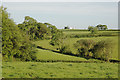
Irregular Grazing Fields
The field boundaries follow natural topography and streams which naturally make the fields smaller and steeper than is optimum for arable cropping.
The building in the distance is High Down SS654231.
Image: © David Brinicombe
Taken: 14 Jun 2015
0.21 miles