IMAGES TAKEN NEAR TO
Warkleigh, UMBERLEIGH, EX37 9DD
Introduction
This page details the photographs taken nearby to EX37 9DD by members of the Geograph project.
The Geograph project started in 2005 with the aim of publishing, organising and preserving representative images for every square kilometre of Great Britain, Ireland and the Isle of Man.

There are currently over 7.5m images from over14,400 individuals and you can help contribute to the project by visiting https://www.geograph.org.uk
Image Map
Images are licensed for reuse under creativecommons.org/licenses/by-sa/2.0
Notes
- Clicking on the map will re-center to the selected point.
- The higher the marker number, the further away the image location is from the centre of the postcode.
Image Listing (18 Images Found)
Images are licensed for reuse under creativecommons.org/licenses/by-sa/2.0
Image
Details
Distance
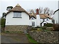
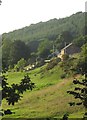
2
Park Farm
The thatched farmhouse is "Probably early C16, remodelled in late C16/early C17" https://historicengland.org.uk/listing/the-list/list-entry/1258623 . This is beside Satterleigh and Warkleigh Bridleway 3.
Image: © Derek Harper
Taken: 22 Aug 2013
0.01 miles
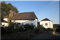
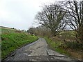
5
Park Farm
Image: © Derek Harper
Taken: 22 Aug 2013
0.06 miles
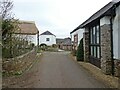
7
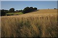
Barley at Park Farm
Most of the farmland along this bridleway (Park Lane) from Spycott is pasture, so this field of ripe barley makes a change.
Image: © Derek Harper
Taken: 22 Aug 2013
0.09 miles
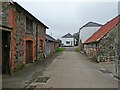
8
Crop near Park Farm
Some sort of beet growing on the slopes of the Taw valley north of Image On the left is Courage Copse.
Image: © Derek Harper
Taken: 22 Aug 2013
0.12 miles
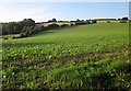
9
Field between Park Lane and railway
In the bottom of the Taw Valley: the river is on the other side of the railway line at this point.
Image: © David Martin
Taken: 25 Apr 2023
0.13 miles
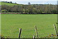
10

Sheep pasture by the Taw
The western side of the field seen in Image]; the River Taw runs along by the trees on the far side.
Image: © Derek Harper
Taken: 22 Aug 2013
0.15 miles