IMAGES TAKEN NEAR TO
Crooked Oaks, SOUTH MOLTON, EX36 4LR
Introduction
This page details the photographs taken nearby to Crooked Oaks, EX36 4LR by members of the Geograph project.
The Geograph project started in 2005 with the aim of publishing, organising and preserving representative images for every square kilometre of Great Britain, Ireland and the Isle of Man.

There are currently over 7.5m images from over14,400 individuals and you can help contribute to the project by visiting https://www.geograph.org.uk
Image Map
Images are licensed for reuse under creativecommons.org/licenses/by-sa/2.0
Notes
- Clicking on the map will re-center to the selected point.
- The higher the marker number, the further away the image location is from the centre of the postcode.
Image Listing (56 Images Found)
Images are licensed for reuse under creativecommons.org/licenses/by-sa/2.0
Image
Details
Distance
1
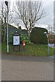
Street furniture in Crooked Oaks, Alswear
Image: © Roger A Smith
Taken: 23 Jan 2014
0.04 miles
2
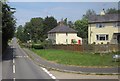
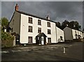
Houses in Alswear
The B3137 at the junction with Crooked Oaks, a cul-de-sac named after one of the two streams that joins the River Mole at Alswear. The building on the right was formerly the police house.
Image: © Derek Harper
Taken: 18 Jul 2013
0.04 miles
3
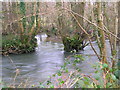
Confluence of the River Mole and Crooked oak
Here the River Mole is joined by the Crooked Oak, the third largest tributary of the river. The Brook rises around a mile and a half East of East Knowstone and meanders through the settelments of Ash mill and Bishops Nympton before it meets the Mole here
Image: © Dylan Inglis
Taken: 18 Feb 2007
0.04 miles
4
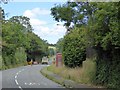
B3137 closed north of Alswear
The sign is on the edge of the village
Image: © David Smith
Taken: 7 Aug 2015
0.05 miles
5

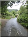
Road from Mariansleigh descending to Alswear
Image: © David Smith
Taken: 7 Aug 2015
0.05 miles
6

Alswear : The B3137
Looking along the B3137 with a telephone box beside the road.
Image: © Lewis Clarke
Taken: 15 Aug 2015
0.05 miles
8
Road into Alswear from Mariansleigh
Looking down the steep road from the east and across the Mole valley
Image: © David Smith
Taken: 19 Jun 2018
0.06 miles
9
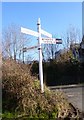
Old Direction Sign - Signpost by the B3137, Alswear
Pyramid cap finial - 4 arms; Devon DCC 'D' pyramid by the B3137, in parish of Meshaw (North Devon District), Alswear, opposite Butcher's Arms PH, on grass opposite car park.
Surveyed
Milestone Society National ID: DV_SS7222
Image: © Alan Rosevear
Taken: 18 Feb 2013
0.06 miles
10
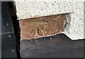
Ordnance Survey Cut Mark
This OS cut mark can be found on the front of the Butchers Arms. It marks a point 85.057m above mean sea level.
Image: © Adrian Dust
Taken: 13 Feb 2017
0.06 miles