IMAGES TAKEN NEAR TO
George Nympton, SOUTH MOLTON, EX36 4JG
Introduction
This page details the photographs taken nearby to EX36 4JG by members of the Geograph project.
The Geograph project started in 2005 with the aim of publishing, organising and preserving representative images for every square kilometre of Great Britain, Ireland and the Isle of Man.

There are currently over 7.5m images from over14,400 individuals and you can help contribute to the project by visiting https://www.geograph.org.uk
Image Map (Loading...)


Getting Data...Please wait
Leaflet Map data © OpenStreetMap
Images are licensed for reuse under creativecommons.org/licenses/by-sa/2.0
Notes
- Clicking on the map will re-center to the selected point.
- The higher the marker number, the further away the image location is from the centre of the postcode.
Image Listing (3 Images Found)
Images are licensed for reuse under creativecommons.org/licenses/by-sa/2.0
Image
Details
Distance
1
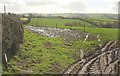
Towards Trayne Farm
Contrejour so not very clear. The farm can also be seen from the other side of the hedge in Image
Image: © Derek Harper
Taken: 8 Feb 2017
0.16 miles
2
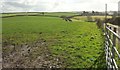
Farmland, Trayne
The farm on the right, shown as "East Trayne" on some scales of map, and "Trayne Farm" on others, is just inside this square, as is the nearer section of the lane leading to it; the stretch you can see over the hill veers into Image
Image: © Derek Harper
Taken: 8 Feb 2017
0.17 miles
3
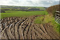
Farmland east of George Nympton
Looking right from the same spot as Image], towards the Mole valley. The lane to George Nympton is behind the hedge on the right.
Image: © Derek Harper
Taken: 8 Feb 2017
0.24 miles