IMAGES TAKEN NEAR TO
George Nympton Road, SOUTH MOLTON, EX36 4ER
Introduction
This page details the photographs taken nearby to George Nympton Road, EX36 4ER by members of the Geograph project.
The Geograph project started in 2005 with the aim of publishing, organising and preserving representative images for every square kilometre of Great Britain, Ireland and the Isle of Man.

There are currently over 7.5m images from over14,400 individuals and you can help contribute to the project by visiting https://www.geograph.org.uk
Image Map (Loading...)


Getting Data...Please wait
Leaflet Map data © OpenStreetMap
Images are licensed for reuse under creativecommons.org/licenses/by-sa/2.0
Notes
- Clicking on the map will re-center to the selected point.
- The higher the marker number, the further away the image location is from the centre of the postcode.
Image Listing (18 Images Found)
Images are licensed for reuse under creativecommons.org/licenses/by-sa/2.0
Image
Details
Distance
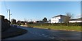
1
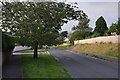
South Molton : George Nympton Road
Looking along George Nympton Road as it heads into South Molton.
Image: © Lewis Clarke
Taken: 26 Jul 2014
0.04 miles
2

South Molton : Meadow Park
Looking along Meadow Park which is a small residential road.
Image: © Lewis Clarke
Taken: 26 Jul 2014
0.05 miles
3

South Molton : Meadow Park
Meadow Park in South Molton.
Image: © Lewis Clarke
Taken: 26 Jul 2014
0.05 miles
4
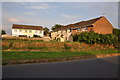
South Molton : Houses
Houses on Stoats Close seen from George Nympton Road.
Image: © Lewis Clarke
Taken: 26 Jul 2014
0.08 miles
5

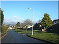
South Molton: Stoats Close
Suburbia on the southern outskirts of the town. Looking east
Image: © Martin Bodman
Taken: 11 Apr 2007
0.11 miles
7
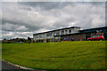
South Molton : South Molton Church of England Primary School
A primary school in South Molton.
Image: © Lewis Clarke
Taken: 17 Jun 2019
0.14 miles
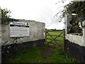
8
Housing and veterinary surgery, B3226, South Molton
The edge of the town, with the vet and housing on the side of the road to the valley of the River Bray
Image: © David Smith
Taken: 9 Dec 2013
0.15 miles
10
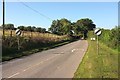
Derestriction signs on the B3226
As the B road leaves the built-up area of South Molton. this is just west of Parklands.
Image: © Derek Harper
Taken: 26 Sep 2015
0.16 miles