IMAGES TAKEN NEAR TO
West Anstey, SOUTH MOLTON, EX36 3NX
Introduction
This page details the photographs taken nearby to EX36 3NX by members of the Geograph project.
The Geograph project started in 2005 with the aim of publishing, organising and preserving representative images for every square kilometre of Great Britain, Ireland and the Isle of Man.

There are currently over 7.5m images from over14,400 individuals and you can help contribute to the project by visiting https://www.geograph.org.uk
Image Map (Loading...)


Getting Data...Please wait
Leaflet Map data © OpenStreetMap
Images are licensed for reuse under creativecommons.org/licenses/by-sa/2.0
Notes
- Clicking on the map will re-center to the selected point.
- The higher the marker number, the further away the image location is from the centre of the postcode.
Image Listing (2 Images Found)
Images are licensed for reuse under creativecommons.org/licenses/by-sa/2.0
Image
Details
Distance
1
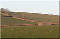
Dutch barn
What it is used for I do not know, but is very prominent while walking along the bridle path, between Netherwell driveway and Combe!
Image: © paul dickson
Taken: 16 Feb 2008
0.14 miles
2
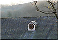
Time for tea
A focal point of the area is this clock on the stable roof at Combe Farm
Image: © paul dickson
Taken: 16 Feb 2008
0.17 miles