IMAGES TAKEN NEAR TO
Heasley Mill, SOUTH MOLTON, EX36 3LE
Introduction
This page details the photographs taken nearby to EX36 3LE by members of the Geograph project.
The Geograph project started in 2005 with the aim of publishing, organising and preserving representative images for every square kilometre of Great Britain, Ireland and the Isle of Man.

There are currently over 7.5m images from over14,400 individuals and you can help contribute to the project by visiting https://www.geograph.org.uk
Image Map (Loading...)


Getting Data...Please wait
Leaflet Map data © OpenStreetMap
Images are licensed for reuse under creativecommons.org/licenses/by-sa/2.0
Notes
- Clicking on the map will re-center to the selected point.
- The higher the marker number, the further away the image location is from the centre of the postcode.
Image Listing (6 Images Found)
Images are licensed for reuse under creativecommons.org/licenses/by-sa/2.0
Image
Details
Distance
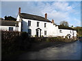
3
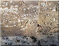
Ordnance Survey Cut Mark
This OS cut mark can be found on the south face of the Hall. It marks a point 194.377m above mean sea level.
Image: © Adrian Dust
Taken: 22 Nov 2018
0.17 miles
6
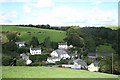
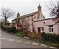
North Molton: Heasley Mill
The hamlet acquired its full name in the late 18th century when a four-storey water-powered woollen factory was established here. It ceased work by 1860 or thereabouts and was demolished by the time of the First World War. It stood on the small green to the right of the Heasley House Hotel, the large Georgian building in the centre of the group. A further watermill beyond the green survives as a house conversion. Looking north east
Image: © Martin Bodman
Taken: 26 Sep 2006
0.22 miles