IMAGES TAKEN NEAR TO
East Street, SOUTH MOLTON, EX36 3HX
Introduction
This page details the photographs taken nearby to East Street, EX36 3HX by members of the Geograph project.
The Geograph project started in 2005 with the aim of publishing, organising and preserving representative images for every square kilometre of Great Britain, Ireland and the Isle of Man.

There are currently over 7.5m images from over14,400 individuals and you can help contribute to the project by visiting https://www.geograph.org.uk
Image Map (Loading...)


Getting Data...Please wait
Leaflet Map data © OpenStreetMap
Images are licensed for reuse under creativecommons.org/licenses/by-sa/2.0
Notes
- Clicking on the map will re-center to the selected point.
- The higher the marker number, the further away the image location is from the centre of the postcode.
Image Listing (58 Images Found)
Images are licensed for reuse under creativecommons.org/licenses/by-sa/2.0
Image
Details
Distance
1

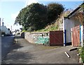
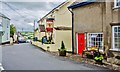
North Molton: Colourful Gardens in East Street
Image: © Mr Eugene Birchall
Taken: 16 Jul 2014
0.01 miles

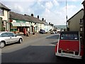
3
Street Scene, North Molton
North Molton is a large village straddling the Exmoor National Park boundary. The place name means the northern settlement on the River Mole. Mole comes from the Celtic moel, meaning a bare, rounded hill.
Image: © Maigheach-gheal
Taken: 12 Mar 2008
0.02 miles
4

Post Office and General Stores, North Molton
Image: © Roger Cornfoot
Taken: 7 May 2014
0.02 miles
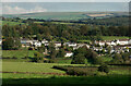
5
Looking across East Street where the Methodist Church is situated
Over the moors some distance is Countisbury.
Image: © Roger A Smith
Taken: 10 Oct 2021
0.03 miles
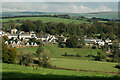
6
Houses on Higher East Street and Jubilee Gardens
Beyond the horizon towards the coast is the village of Brendon.
Image: © Roger A Smith
Taken: 10 Oct 2021
0.04 miles
7
Western end of East Street, North Molton
Image: © David Gearing
Taken: 23 Sep 2014
0.04 miles
8
North Molton: The Poltimore Inn in East Street
Image: © Mr Eugene Birchall
Taken: 16 Jul 2014
0.04 miles
9
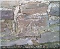
Ordnance Survey Cut Mark
This OS cut mark can be found on the outbuilding at Holdridge, East Street. It marks a point 185.556m above mean sea level.
Image: © Adrian Dust
Taken: 22 Nov 2018
0.06 miles
10
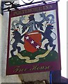
Sign for the Poltimore Inn, North Molton
Image: © Maigheach-gheal
Taken: 12 Mar 2008
0.06 miles