IMAGES TAKEN NEAR TO
Closewool Grove, EX36 3GA
Introduction
This page details the photographs taken nearby to Closewool Grove, EX36 3GA by members of the Geograph project.
The Geograph project started in 2005 with the aim of publishing, organising and preserving representative images for every square kilometre of Great Britain, Ireland and the Isle of Man.

There are currently over 7.5m images from over14,400 individuals and you can help contribute to the project by visiting https://www.geograph.org.uk
Image Map (Loading...)


Getting Data...Please wait
Leaflet Map data © OpenStreetMap
Images are licensed for reuse under creativecommons.org/licenses/by-sa/2.0
Notes
- Clicking on the map will re-center to the selected point.
- The higher the marker number, the further away the image location is from the centre of the postcode.
Image Listing (30 Images Found)
Images are licensed for reuse under creativecommons.org/licenses/by-sa/2.0
Image
Details
Distance
1

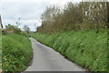
South Molton : Frog Lane
Looking to path of grassy area known as Frog Lane.
Image: © Lewis Clarke
Taken: 15 Dec 2021
0.05 miles
2

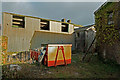
The Bee Meadow Estate under construction
Image: © Roger A Smith
Taken: 11 May 2023
0.06 miles
3
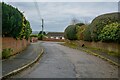
Gunswell Lane
New housing is being constructed above the bank on the right.
Image: © David Martin
Taken: 24 Apr 2023
0.07 miles
4
South Molton : Gunswell Lane
A small road off Gunswell Lane.
Image: © Lewis Clarke
Taken: 15 Dec 2021
0.07 miles
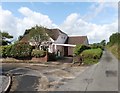
7

Quince Honey farm on North West corner of South Molton
Image: © Ivan Taylor
Taken: 23 Nov 2005
0.11 miles
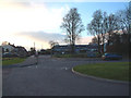
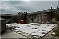
8

The Old Workhouse, now a housing development
See also: Image
Image: © Roger A Smith
Taken: 10 Jul 2021
0.13 miles
9
The old Quince Honey Farm, North Road, South Molton
See also: Image
Image: © Roger A Smith
Taken: 9 Jan 2020
0.13 miles
10
The old Quince Honey Farm, North Road, South Molton
Image: © Roger A Smith
Taken: 8 Aug 2019
0.14 miles