IMAGES TAKEN NEAR TO
Tawny Close, SOUTH MOLTON, EX36 3FS
Introduction
This page details the photographs taken nearby to Tawny Close, EX36 3FS by members of the Geograph project.
The Geograph project started in 2005 with the aim of publishing, organising and preserving representative images for every square kilometre of Great Britain, Ireland and the Isle of Man.

There are currently over 7.5m images from over14,400 individuals and you can help contribute to the project by visiting https://www.geograph.org.uk
Image Map
Images are licensed for reuse under creativecommons.org/licenses/by-sa/2.0
Notes
- Clicking on the map will re-center to the selected point.
- The higher the marker number, the further away the image location is from the centre of the postcode.
Image Listing (37 Images Found)
Images are licensed for reuse under creativecommons.org/licenses/by-sa/2.0
Image
Details
Distance
1

Junction with Hacche Lane
The Lane leads north behind the green car
Image: © David Smith
Taken: 1 Mar 2012
0.03 miles
2

South Molton : Bee Meadow
A new housing estate on the outskirts of South Molton.
Image: © Lewis Clarke
Taken: 19 Sep 2018
0.04 miles
3

South Molton : Bee Meadow
A new housing estate on the outskirts of South Molton.
Image: © Lewis Clarke
Taken: 19 Sep 2018
0.04 miles
4
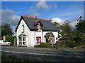
Old Toll House by North Road, South Molton
Toll House by the B3226, in the parish of South Molton (North Devon District), Vicarage Lodge, North Road, Pathfields, EX36.
Grade II listed.
List Entry Number: 1106850 https://historicengland.org.uk/listing/the-list/list-entry/1106850
Surveyed
Milestone Society National ID: DV.SMO04
Image: © Alan Rosevear
Taken: 22 Oct 2005
0.04 miles
5

South Molton : Bee Meadow
A new housing estate on the outskirts of South Molton.
Image: © Lewis Clarke
Taken: 19 Sep 2018
0.05 miles
6
Ordnance Survey Rivet
This OS rivet can be found on the concrete base of the seat to the west of North Street. It marks a point 150.938m above mean sea level.
Image: © Adrian Dust
Taken: 17 Feb 2014
0.09 miles
7

North Road, South Molton
The B3226 leaves South Molton past the Quince Honey Farm - the bright hives along the verge are the giveaway.
Image: © Derek Harper
Taken: 18 Jul 2013
0.11 miles
8

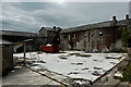
The Old Workhouse, now a housing development
See also: Image
Image: © Roger A Smith
Taken: 10 Jul 2021
0.14 miles
9
The old Quince Honey Farm, North Road, South Molton
Image: © Roger A Smith
Taken: 8 Aug 2019
0.14 miles
10
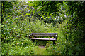
South Molton : Community Woodland
A bench in the Community Woodland.
Image: © Lewis Clarke
Taken: 31 Jul 2021
0.14 miles