IMAGES TAKEN NEAR TO
Barnstaple Street, SOUTH MOLTON, EX36 3BQ
Introduction
This page details the photographs taken nearby to Barnstaple Street, EX36 3BQ by members of the Geograph project.
The Geograph project started in 2005 with the aim of publishing, organising and preserving representative images for every square kilometre of Great Britain, Ireland and the Isle of Man.

There are currently over 7.5m images from over14,400 individuals and you can help contribute to the project by visiting https://www.geograph.org.uk
Image Map (Loading...)


Getting Data...Please wait
Leaflet Map data © OpenStreetMap
Images are licensed for reuse under creativecommons.org/licenses/by-sa/2.0
Notes
- Clicking on the map will re-center to the selected point.
- The higher the marker number, the further away the image location is from the centre of the postcode.
Image Listing (271 Images Found)
Images are licensed for reuse under creativecommons.org/licenses/by-sa/2.0
Image
Details
Distance
1
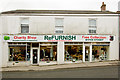
The ReFurnish charity shop in South Molton
8 & 9 Barnstaple Street
South Molton
Devon
EX36 3BQ
https://www.refurnish.org.uk
Image: © Roger A Smith
Taken: 23 Mar 2018
0.02 miles
2
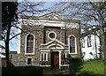
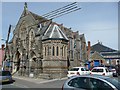
The Congregational Chapel, South Molton
A mid-19C building. The date 1605 on the pediment is presumably that the formation of the congregation (which was illegal at that time so they would have met in secret).
Image: © Humphrey Bolton
Taken: 11 Apr 2010
0.02 miles
3
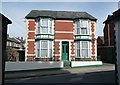
House, North Street, South Molton
A bright house framed by a shady passage from the churchyard.
Image: © Humphrey Bolton
Taken: 11 Apr 2010
0.02 miles
4
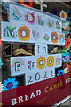
South Molton : Chanters Bakery
A display for South Molton in Bloom in the shop window.
Image: © Lewis Clarke
Taken: 13 Jul 2021
0.03 miles
5

South Molton
This is close to the centre of the village at the junction of King St in the foreground and Barnstaple St in the background. The street may be named after the pub or vice versa.
Image: © Nigel Mykura
Taken: 24 May 2012
0.04 miles
6

Ordnance Survey Cut Mark
This OS cut mark can be found on the wall of the Old Primary School, North Street, at the junction of roads. It marks a point 141.296m above mean sea level.
Image: © Adrian Dust
Taken: 16 Feb 2014
0.04 miles
7

Kings Arms South Molton
Decked out with George Cross flags large and small, the pub may be an early celebrant of the Queens Jubilee but the advertisement poster for Sky TV sports being shown at the pub mean it is more likely to be sports related.
Image: © Nigel Mykura
Taken: 24 May 2012
0.04 miles
8
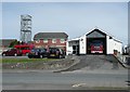
The Fire Station, North Street, South Molton
The practice tower looks like a cage.
Image: © Humphrey Bolton
Taken: 11 Apr 2010
0.05 miles
9
Methodist Chapel, North Street, South Molton
Very ornate, with statues of angels.
Image: © Humphrey Bolton
Taken: 11 Apr 2010
0.05 miles
10
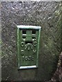
Ordnance Survey Flush Bracket (1638)
This OS Flush Bracket, 1638, can be found on the SW corner of the church. It marks a point 144.188m above mean sea level. It was included on the Dulverton to Torrington levelling line.
Image: © Adrian Dust
Taken: 17 Feb 2014
0.05 miles