IMAGES TAKEN NEAR TO
Church Street, SOUTH MOLTON, EX36 3BN
Introduction
This page details the photographs taken nearby to Church Street, EX36 3BN by members of the Geograph project.
The Geograph project started in 2005 with the aim of publishing, organising and preserving representative images for every square kilometre of Great Britain, Ireland and the Isle of Man.

There are currently over 7.5m images from over14,400 individuals and you can help contribute to the project by visiting https://www.geograph.org.uk
Image Map (Loading...)


Getting Data...Please wait
Leaflet Map data © OpenStreetMap
Images are licensed for reuse under creativecommons.org/licenses/by-sa/2.0
Notes
- Clicking on the map will re-center to the selected point.
- The higher the marker number, the further away the image location is from the centre of the postcode.
Image Listing (298 Images Found)
Images are licensed for reuse under creativecommons.org/licenses/by-sa/2.0
Image
Details
Distance
1

North Devon Hospice Charity Shop, 17 Broad Street, South Molton, EX36 3AQ
Image: © Roger A Smith
Taken: 26 Mar 2021
0.02 miles
2

Devon Air Ambulance charity shop, 19, Broad street, South Molton
Image: © Roger A Smith
Taken: 23 Aug 2014
0.02 miles
3

Kings Arms South Molton
Decked out with George Cross flags large and small, the pub may be an early celebrant of the Queens Jubilee but the advertisement poster for Sky TV sports being shown at the pub mean it is more likely to be sports related.
Image: © Nigel Mykura
Taken: 24 May 2012
0.02 miles
4

The tower of South Molton church from North Street
Image: © David Smith
Taken: 9 Dec 2013
0.03 miles
5
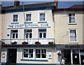
Constitutional Club, South Molton
Glimpsed out of a bus window, but not already on the site, so as one of South Molton's more striking buildings, with its "good cast iron balcony" http://list.english-heritage.org.uk/resultsingle.aspx?uid=1164161 , it seems worth submitting. The description gives its date as c. 1840.
Image: © Derek Harper
Taken: 18 Jul 2013
0.03 miles
6
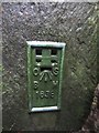
Ordnance Survey Flush Bracket (1638)
This OS Flush Bracket, 1638, can be found on the SW corner of the church. It marks a point 144.188m above mean sea level. It was included on the Dulverton to Torrington levelling line.
Image: © Adrian Dust
Taken: 17 Feb 2014
0.03 miles
7

South Molton : St Mary Magdalene Church
The current building is believed to be the third church on this site, but it is not known when the first was built. The Domesday Book entry may indicate a church stood here at that time, but does not expressly refer to one.
The second is thought to have dated from between 1150 and 1270. The unusually thick walls of the chancel are thought to be 800 years old, and to be a remnant of that building.
A newly appointed Rector in 1410 complained to the Bishop of the grievous dilapidation of the chancel. It is likely that this was renovated, and then incorporated into the new church that was built over many years during the late 15th C.
Image: © Lewis Clarke
Taken: 19 Apr 2018
0.03 miles
8
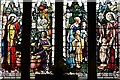
South Molton, St. Mary Magdalene's Church: Stained glass window
Image: © Michael Garlick
Taken: 15 Apr 2018
0.03 miles
9

South Molton, St. Mary Magdalene's Church: Corbel 1
Image: © Michael Garlick
Taken: 15 Apr 2018
0.03 miles
10

South Molton, St. Mary Magdalene's Church: Corbel 1 (from a different viewpoint)
Image: © Michael Garlick
Taken: 15 Apr 2018
0.03 miles