IMAGES TAKEN NEAR TO
LYNTON, EX35 6PZ
Introduction
This page details the photographs taken nearby to EX35 6PZ by members of the Geograph project.
The Geograph project started in 2005 with the aim of publishing, organising and preserving representative images for every square kilometre of Great Britain, Ireland and the Isle of Man.

There are currently over 7.5m images from over14,400 individuals and you can help contribute to the project by visiting https://www.geograph.org.uk
Image Map
Images are licensed for reuse under creativecommons.org/licenses/by-sa/2.0
Notes
- Clicking on the map will re-center to the selected point.
- The higher the marker number, the further away the image location is from the centre of the postcode.
Image Listing (8 Images Found)
Images are licensed for reuse under creativecommons.org/licenses/by-sa/2.0
Image
Details
Distance
1
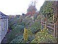
Public footpath through the garden, at Thornworthy
Image: © Roger Cornfoot
Taken: 8 Jan 2015
0.00 miles
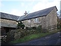
3

Thornworthy
From the path to High Bullen.
Image: © Roger Gittins
Taken: 24 May 2007
0.03 miles
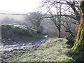
5

Thornworthy Ford
This ford on Barbrook is found at Thornworthy.
Image: © John Walton
Taken: 4 May 2021
0.09 miles
6
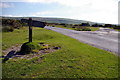
Road to Thornworthy
Signpost reads:
Right:
Public Bridleway
Martinhoe Cross A39
Via Thornworthy &
Woolhanger 2¼
Left:
Sparhanger
Cross
Image: © Roger Gittins
Taken: 24 May 2007
0.14 miles
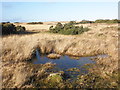
8
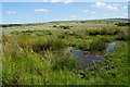
Boggy bit on Ilkerton Ridge
A reminder that this end of the common land is still quite wild.
Image: © Bill Boaden
Taken: 5 Jul 2017
0.17 miles