IMAGES TAKEN NEAR TO
LYNTON, EX35 6JW
Introduction
This page details the photographs taken nearby to EX35 6JW by members of the Geograph project.
The Geograph project started in 2005 with the aim of publishing, organising and preserving representative images for every square kilometre of Great Britain, Ireland and the Isle of Man.

There are currently over 7.5m images from over14,400 individuals and you can help contribute to the project by visiting https://www.geograph.org.uk
Image Map (27 Images)


Getting Data...Please wait
Leaflet Map data © OpenStreetMap
Images are licensed for reuse under creativecommons.org/licenses/by-sa/2.0
Notes
- Clicking on the map will re-center to the selected point.
- The higher the marker number, the further away the image location is from the centre of the postcode.
Image Listing (27 Images Found)
Images are licensed for reuse under creativecommons.org/licenses/by-sa/2.0
Image
Details
Distance
1
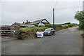
Croscombe Bungalow
Bungalow opposite South Croscombe Farm.
Image: © Ian Capper
Taken: 20 Jun 2018
0.01 miles
2
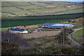
Martinhoe : South Croscombe Farm
Looking towards farm buildings.
Image: © Lewis Clarke
Taken: 6 Apr 2021
0.04 miles
3
Croscombe Barton
Lane leading to Croscombe Barton (see Image).
Image: © Ian Capper
Taken: 20 Jun 2018
0.07 miles
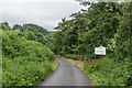
5
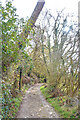
Lynton : Track
A track heads through the countryside.
Image: © Lewis Clarke
Taken: 6 Apr 2021
0.13 miles
6
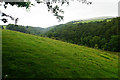
Combe above Bonhill Bridge
The combe will descend towards Lee Bay. There is a hint of rain in the air.
Image: © Bill Boaden
Taken: 7 Jul 2017
0.14 miles
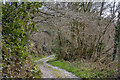
7
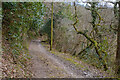
Lynton : Track
A track heads through the countryside.
Image: © Lewis Clarke
Taken: 6 Apr 2021
0.15 miles
8
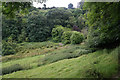
Combe below Croscombe Barton
The combe deepens and descends more steeply down to Lee Bay, to the left. This is looking along the route of an alternative footpath which is not marked on the OS map, and is not entirely clearly waymarked.
Image: © Bill Boaden
Taken: 7 Jul 2017
0.16 miles
9
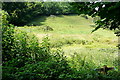
Combe at Croscombe Barton
From the bridleway the footpath to Slattenslade is signposted across this field to the gate at the head of the combe. It seems to be little used.
Image: © Graham Horn
Taken: 23 Jul 2010
0.16 miles
10
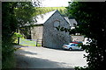
Croscombe Barton
Some of the farm buildings, at the point where the bridleway emerges from Bonhill Wood and takes a sharp turn to the left.
Image: © Graham Horn
Taken: 23 Jul 2010
0.17 miles