IMAGES TAKEN NEAR TO
Summerhouse Path, LYNMOUTH, EX35 6ES
Introduction
This page details the photographs taken nearby to Summerhouse Path, EX35 6ES by members of the Geograph project.
The Geograph project started in 2005 with the aim of publishing, organising and preserving representative images for every square kilometre of Great Britain, Ireland and the Isle of Man.

There are currently over 7.5m images from over14,400 individuals and you can help contribute to the project by visiting https://www.geograph.org.uk
Image Map
Images are licensed for reuse under creativecommons.org/licenses/by-sa/2.0
Notes
- Clicking on the map will re-center to the selected point.
- The higher the marker number, the further away the image location is from the centre of the postcode.
Image Listing (812 Images Found)
Images are licensed for reuse under creativecommons.org/licenses/by-sa/2.0
Image
Details
Distance

6
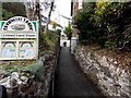
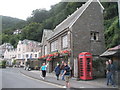
Bonnicott House name sign, Lynmouth
Licensed guest house, Watersmeet Road.
Image: © Jaggery
Taken: 24 Sep 2014
0.02 miles
7
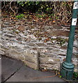
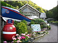
Two Moors Way name stone, Lynmouth
On the pavement above the A39 Watersmeet Road.
Image: © Jaggery
Taken: 24 Sep 2014
0.02 miles
8
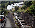
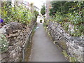
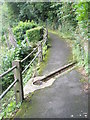
Steps up to Bonnicott House, Lynmouth
Licensed guest house above Watersmeet Road.
Image: © Jaggery
Taken: 24 Sep 2014
0.02 miles