IMAGES TAKEN NEAR TO
ILFRACOMBE, EX34 9RW
Introduction
This page details the photographs taken nearby to EX34 9RW by members of the Geograph project.
The Geograph project started in 2005 with the aim of publishing, organising and preserving representative images for every square kilometre of Great Britain, Ireland and the Isle of Man.

There are currently over 7.5m images from over14,400 individuals and you can help contribute to the project by visiting https://www.geograph.org.uk
Image Map
Images are licensed for reuse under creativecommons.org/licenses/by-sa/2.0
Notes
- Clicking on the map will re-center to the selected point.
- The higher the marker number, the further away the image location is from the centre of the postcode.
Image Listing (4 Images Found)
Images are licensed for reuse under creativecommons.org/licenses/by-sa/2.0
Image
Details
Distance
1
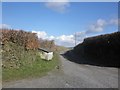
Keypitts Farm
This farm has diversified and now offers horse riding and quad bike rides to visitors.
Image: © Roger A Smith
Taken: 28 May 2014
0.00 miles
2
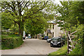
Keypitts Farm from Oxenpark Lane
With Hillsborough Image in the distance.
Image: © Grant Sherman
Taken: 21 Nov 2005
0.06 miles
3
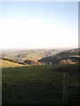
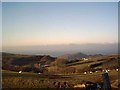
View of Sterridge Valley from Oxenpark Lane
Taken near Higher Cockhill Farm.
Image: © Grant Sherman
Taken: 21 Nov 2005
0.21 miles