IMAGES TAKEN NEAR TO
ILFRACOMBE, EX34 9RT
Introduction
This page details the photographs taken nearby to EX34 9RT by members of the Geograph project.
The Geograph project started in 2005 with the aim of publishing, organising and preserving representative images for every square kilometre of Great Britain, Ireland and the Isle of Man.

There are currently over 7.5m images from over14,400 individuals and you can help contribute to the project by visiting https://www.geograph.org.uk
Image Map (Loading...)


Getting Data...Please wait
Leaflet Map data © OpenStreetMap
Images are licensed for reuse under creativecommons.org/licenses/by-sa/2.0
Notes
- Clicking on the map will re-center to the selected point.
- The higher the marker number, the further away the image location is from the centre of the postcode.
Image Listing (22 Images Found)
Images are licensed for reuse under creativecommons.org/licenses/by-sa/2.0
Image
Details
Distance
1
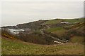
The A399 at Hele (pronounced "heal")
West Haggington beach is on the left, Ilfracombe golf club house on the right and just faintly visible are the coastguard cottages on the ridge, left of centre.
Image: © Roger A Smith
Taken: 31 Mar 2009
0.02 miles
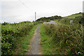
2

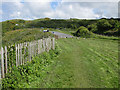
South West Coast Path above Hele Bay
The path has to follow the A399 for a short stretch. The A road has been straightened here, though you cannot easily tell.
Image: © Bill Boaden
Taken: 13 Jul 2020
0.09 miles

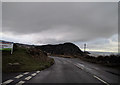
4

A399 above Hele Bay and Rillage Point
The road is climbing over the back of Rillage Point. The picture shows a wooden signpost for the South West Coast Path.
Image: © David Smith
Taken: 20 Aug 2013
0.09 miles
5
South West Coast Path near Ilfracombe Golf Club
The main OS maps signify a 360 degree viewpoint here, which is a bit mystifying. You can get a reasonable view over Hele Bay but it is certainly not an all round one. The coast path is forced to follow the edge of the A399 for a short stretch.
Image: © Bill Boaden
Taken: 13 Jul 2020
0.10 miles
6
On the A399, approaching Ilfracombe from the east
Image: © Rob Purvis
Taken: 5 Jan 2018
0.10 miles
7
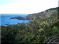
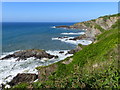
Cliff top vegetation above Hele Bay
A mixture of bracken and brambles and the invasive Japanese Knotweed. In the background is Rillage Point in square Image
Image: © Rod Allday
Taken: 25 Sep 2010
0.15 miles
8

North Devon : The A399
Most of the A399, a medium-length A-road in north Devon, runs along the western section of Exmoor National Park.
Image: © Lewis Clarke
Taken: 23 Aug 2014
0.16 miles
9
Haggington Point Viewpoint
Beside the A399.
Good views of Beacon Point, Hele Bay, Hillsborough Down and Rillage Point.
Haggington Point is not named on any of my maps but the name is displayed on an information board by the telescope in the small car park.
Image: © Pauline E
Taken: 19 May 2009
0.16 miles
10
Coastline seen from lay-by east of Ilfracombe
Image: © Ruth Sharville
Taken: 14 Jun 2018
0.17 miles