IMAGES TAKEN NEAR TO
High Street, ILFRACOMBE, EX34 9NG
Introduction
This page details the photographs taken nearby to High Street, EX34 9NG by members of the Geograph project.
The Geograph project started in 2005 with the aim of publishing, organising and preserving representative images for every square kilometre of Great Britain, Ireland and the Isle of Man.

There are currently over 7.5m images from over14,400 individuals and you can help contribute to the project by visiting https://www.geograph.org.uk
Image Map
Images are licensed for reuse under creativecommons.org/licenses/by-sa/2.0
Notes
- Clicking on the map will re-center to the selected point.
- The higher the marker number, the further away the image location is from the centre of the postcode.
Image Listing (1039 Images Found)
Images are licensed for reuse under creativecommons.org/licenses/by-sa/2.0
Image
Details
Distance
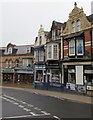
1
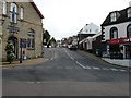
Marlborough Road at the junction with the High Street
Image: © Roger A Smith
Taken: 4 Sep 2008
0.01 miles
2
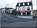
The Marlboro, No. 71 The High Street, Ilfracombe.
Image: © Roger A Smith
Taken: 18 Jan 2009
0.01 miles
3
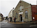
Encounter Church, 74 High Street, Ilfracombe
A Charismatic Church viewed in June 2017. The church recently changed its name.
It used to be Ilfracombe Christian Fellowship Church, seen here http://www.geograph.org.uk/photo/1268108 in 2009.
Image: © Jaggery
Taken: 25 Jun 2017
0.01 miles
4

A 2 B Taxi Office, No. 72 The High Street, Ilfracombe.
The High Street numbering becomes confusing here as this property is on Marlborough Road.
Image: © Roger A Smith
Taken: 18 Jan 2009
0.01 miles
5
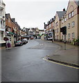
Church Street Ilfracombe
From the corner of Horne Road along the A361 Church Street towards High Street.
Image: © Jaggery
Taken: 25 Jun 2017
0.01 miles
6

Church Street
The centre of Ilfracombe but it is unnaturally quiet. Not only is it a wet day, but it is still showing the effects of the coronavirus lockdown.
Image: © Bill Boaden
Taken: 13 Jul 2020
0.01 miles
7

Ordnance Survey Cut Mark
This OS cut mark can be found on the Christian Fellowship Church Hall, High Street. It marks a point 28.100m above mean sea level.
Image: © Adrian Dust
Taken: 17 Feb 2014
0.02 miles

9
Manor House Cafe, Ilfracombe
On the right at 70 High Street opposite Marlborough Road.
Image: © Jaggery
Taken: 25 Jun 2017
0.02 miles
10
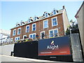
Alight on Church Street
The wedge-shaped street was the place where two conventional advertising boards used to be; today the modern world has come to Ilfracombe and now there is a single digital display, changing every few moments.
Image: © Neil Owen
Taken: 9 Aug 2022
0.02 miles