IMAGES TAKEN NEAR TO
Orchard Road, ILFRACOMBE, EX34 9JY
Introduction
This page details the photographs taken nearby to Orchard Road, EX34 9JY by members of the Geograph project.
The Geograph project started in 2005 with the aim of publishing, organising and preserving representative images for every square kilometre of Great Britain, Ireland and the Isle of Man.

There are currently over 7.5m images from over14,400 individuals and you can help contribute to the project by visiting https://www.geograph.org.uk
Image Map (Loading...)


Getting Data...Please wait
Leaflet Map data © OpenStreetMap
Images are licensed for reuse under creativecommons.org/licenses/by-sa/2.0
Notes
- Clicking on the map will re-center to the selected point.
- The higher the marker number, the further away the image location is from the centre of the postcode.
Image Listing (939 Images Found)
Images are licensed for reuse under creativecommons.org/licenses/by-sa/2.0
Image
Details
Distance

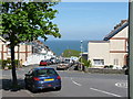
2
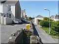
The lower part of Cambridge Grove leading towards Hostel Park Road.
Image: © Roger A Smith
Taken: 19 May 2008
0.02 miles
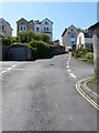
4

Part of Cambridge Grove leading down from Highfield Road
Image: © Roger A Smith
Taken: 19 May 2008
0.02 miles
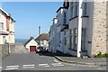
5
Hostel Park Road at the junction with Cambridge Grove (left).
Image: © Roger A Smith
Taken: 19 May 2008
0.03 miles
6
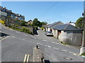
Cambridge Grove meets Hostel Park Road rising steeply to the left.
Image: © Roger A Smith
Taken: 19 May 2008
0.03 miles

8
The junction of Whitingham road, Highfield road and Cambridge grove
Image: © Roger A Smith
Taken: 19 May 2008
0.04 miles
9

Montpelier Terrace - Hostle Park Road
Image: © Betty Longbottom
Taken: 10 May 2017
0.04 miles
